You are here: Home > Network List > TA - USArray Transportable Network (new EarthScope stations) Stations List
> Station J34A George, IA, USA > Earthquake Result Viewer
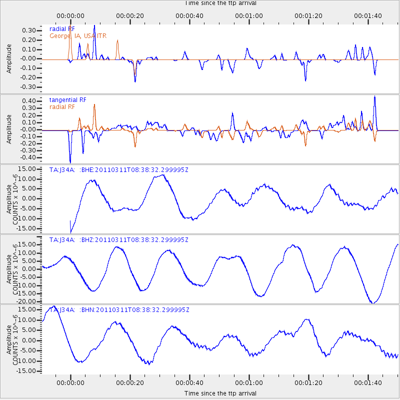
J34A George, IA, USA - Earthquake Result Viewer
*The percent match for this event was below the threshold and hence no stack was calculated.
| Earthquake location: |
Off East Coast Of Honshu, Japan |
| Earthquake latitude/longitude: |
37.4/143.0 |
| Earthquake time(UTC): |
2011/03/11 (070) 08:26:36 GMT |
| Earthquake Depth: |
17 km |
| Earthquake Magnitude: |
6.1 MB |
| Earthquake Catalog/Contributor: |
WHDF/NEIC |
|
| Network: |
TA USArray Transportable Network (new EarthScope stations) |
| Station: |
J34A George, IA, USA |
| Lat/Lon: |
43.28 N/95.96 W |
| Elevation: |
432 m |
|
| Distance: |
83.5 deg |
| Az: |
39.037 deg |
| Baz: |
316.595 deg |
| Ray Param: |
$rayparam |
*The percent match for this event was below the threshold and hence was not used in the summary stack. |
|
| Radial Match: |
67.10044 % |
| Radial Bump: |
339 |
| Transverse Match: |
66.24523 % |
| Transverse Bump: |
400 |
| SOD ConfigId: |
356183 |
| Insert Time: |
2011-08-13 11:12:06.767 +0000 |
| GWidth: |
2.5 |
| Max Bumps: |
400 |
| Tol: |
0.001 |
|
Signal To Noise
| Channel | StoN | STA | LTA |
| TA:J34A: :BHZ:20110311T08:38:32.299995Z | 0.6657994 | 4.7830595E-6 | 7.1839354E-6 |
| TA:J34A: :BHN:20110311T08:38:32.299995Z | 1.0924159 | 8.28306E-6 | 7.5823323E-6 |
| TA:J34A: :BHE:20110311T08:38:32.299995Z | 1.8125818 | 1.1446687E-5 | 6.3151288E-6 |
| Arrivals |
| Ps | |
| PpPs | |
| PsPs/PpSs | |


