You are here: Home > Network List > AZ - ANZA Regional Network Stations List
> Station LVA2 AZ.LVA2 > Earthquake Result Viewer
LVA2 AZ.LVA2 - Earthquake Result Viewer
| Earthquake location: |
Kamchatka Peninsula, Russia |
| Earthquake latitude/longitude: |
55.7/160.0 |
| Earthquake time(UTC): |
2004/06/10 (162) 15:19:57 GMT |
| Earthquake Depth: |
189 km |
| Earthquake Magnitude: |
6.1 MB, 6.9 MW, 6.9 MW |
| Earthquake Catalog/Contributor: |
WHDF/NEIC |
|
| Network: |
AZ ANZA Regional Network |
| Station: |
LVA2 AZ.LVA2 |
| Lat/Lon: |
33.35 N/116.56 W |
| Elevation: |
1435 m |
|
| Distance: |
59.7 deg |
| Az: |
74.471 deg |
| Baz: |
319.31 deg |
| Ray Param: |
0.06144106 |
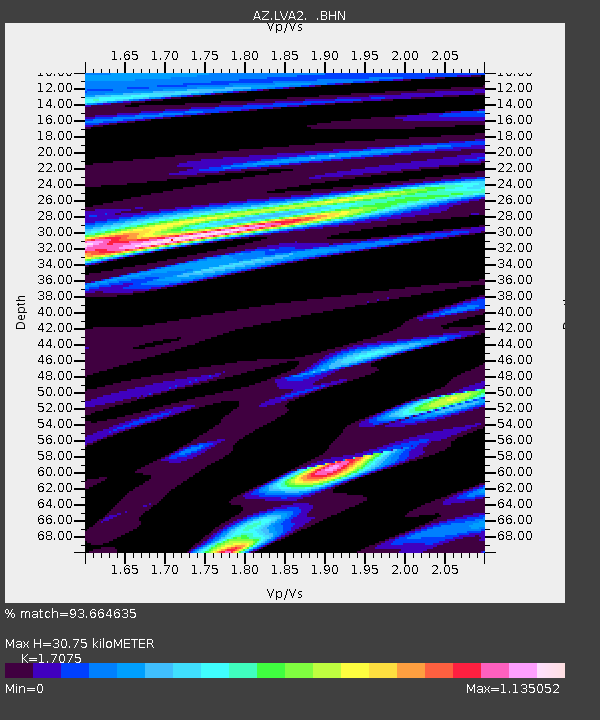
| Estimated Moho Depth: |
30.75 km |
| Estimated Crust Vp/Vs: |
1.71 |
| Assumed Crust Vp: |
6.264 km/s |
| Estimated Crust Vs: |
3.668 km/s |
| Estimated Crust Poisson's Ratio: |
0.24 |
|
| Radial Match: |
93.664635 % |
| Radial Bump: |
400 |
| Transverse Match: |
77.89504 % |
| Transverse Bump: |
400 |
| SOD ConfigId: |
2459 |
| Insert Time: |
2010-02-26 19:45:52.917 +0000 |
| GWidth: |
2.5 |
| Max Bumps: |
400 |
| Tol: |
0.001 |
|
Signal To Noise
| Channel | StoN | STA | LTA |
| AZ:LVA2: :BHN:20040610T15:29:11.299011Z | 6.5398893 | 1.4749278E-6 | 2.2552794E-7 |
| AZ:LVA2: :BHE:20040610T15:29:11.299011Z | 4.7898374 | 8.6654273E-7 | 1.8091278E-7 |
| AZ:LVA2: :BHZ:20040610T15:29:11.299011Z | 25.901749 | 3.8119272E-6 | 1.4716873E-7 |
| Arrivals |
| Ps | 3.6 SECOND |
| PpPs | 13 SECOND |
| PsPs/PpSs | 16 SECOND |


