You are here: Home > Network List > TA - USArray Transportable Network (new EarthScope stations) Stations List
> Station O38A Galt, MO, USA > Earthquake Result Viewer
O38A Galt, MO, USA - Earthquake Result Viewer
| Earthquake location: |
Off East Coast Of Honshu, Japan |
| Earthquake latitude/longitude: |
37.4/143.0 |
| Earthquake time(UTC): |
2011/03/11 (070) 08:26:36 GMT |
| Earthquake Depth: |
17 km |
| Earthquake Magnitude: |
6.1 MB |
| Earthquake Catalog/Contributor: |
WHDF/NEIC |
|
| Network: |
TA USArray Transportable Network (new EarthScope stations) |
| Station: |
O38A Galt, MO, USA |
| Lat/Lon: |
40.12 N/93.47 W |
| Elevation: |
266 m |
|
| Distance: |
87.1 deg |
| Az: |
39.805 deg |
| Baz: |
318.306 deg |
| Ray Param: |
0.043557394 |
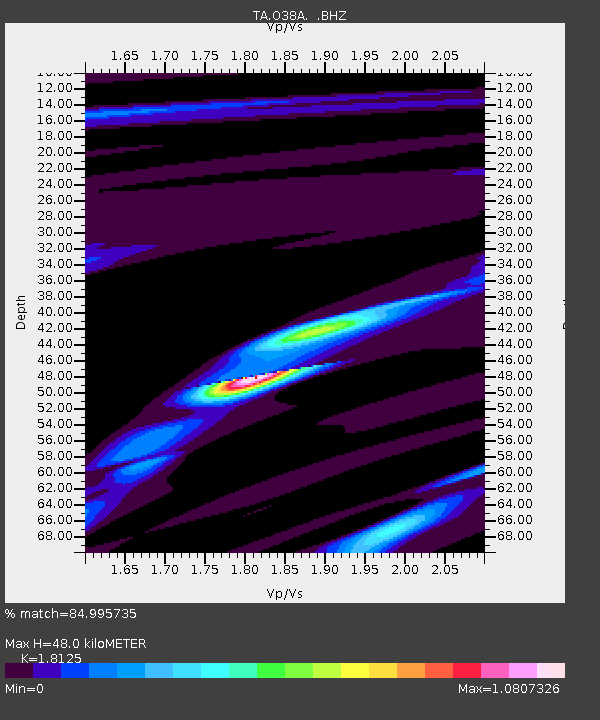
| Estimated Moho Depth: |
48.0 km |
| Estimated Crust Vp/Vs: |
1.81 |
| Assumed Crust Vp: |
6.498 km/s |
| Estimated Crust Vs: |
3.585 km/s |
| Estimated Crust Poisson's Ratio: |
0.28 |
|
| Radial Match: |
84.995735 % |
| Radial Bump: |
203 |
| Transverse Match: |
69.3462 % |
| Transverse Bump: |
397 |
| SOD ConfigId: |
356183 |
| Insert Time: |
2011-08-13 11:26:41.608 +0000 |
| GWidth: |
2.5 |
| Max Bumps: |
400 |
| Tol: |
0.001 |
|

Signal To Noise
| Channel | StoN | STA | LTA |
| TA:O38A: :BHZ:20110311T08:38:50.125007Z | 1.5047432 | 1.847016E-5 | 1.2274626E-5 |
| TA:O38A: :BHN:20110311T08:38:50.125007Z | 0.9874377 | 6.2041827E-6 | 6.2831127E-6 |
| TA:O38A: :BHE:20110311T08:38:50.125007Z | 1.1662383 | 9.423227E-6 | 8.080018E-6 |
| Arrivals |
| Ps | 6.1 SECOND |
| PpPs | 20 SECOND |
| PsPs/PpSs | 26 SECOND |


