You are here: Home > Network List > UW - Pacific Northwest Regional Seismic Network Stations List
> Station UMAT Pilot Rock, OR, USA > Earthquake Result Viewer
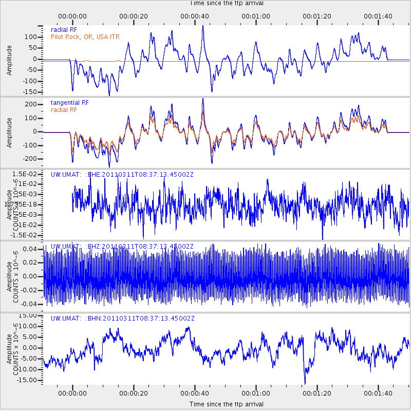
UMAT Pilot Rock, OR, USA - Earthquake Result Viewer
*The percent match for this event was below the threshold and hence no stack was calculated.
| Earthquake location: |
Off East Coast Of Honshu, Japan |
| Earthquake latitude/longitude: |
37.4/143.0 |
| Earthquake time(UTC): |
2011/03/11 (070) 08:26:36 GMT |
| Earthquake Depth: |
17 km |
| Earthquake Magnitude: |
6.1 MB |
| Earthquake Catalog/Contributor: |
WHDF/NEIC |
|
| Network: |
UW Pacific Northwest Regional Seismic Network |
| Station: |
UMAT Pilot Rock, OR, USA |
| Lat/Lon: |
45.29 N/118.96 W |
| Elevation: |
1318 m |
|
| Distance: |
69.5 deg |
| Az: |
48.25 deg |
| Baz: |
302.643 deg |
| Ray Param: |
$rayparam |
*The percent match for this event was below the threshold and hence was not used in the summary stack. |
|
| Radial Match: |
33.458553 % |
| Radial Bump: |
384 |
| Transverse Match: |
33.45909 % |
| Transverse Bump: |
367 |
| SOD ConfigId: |
356183 |
| Insert Time: |
2011-08-13 11:49:15.986 +0000 |
| GWidth: |
2.5 |
| Max Bumps: |
400 |
| Tol: |
0.001 |
|
Signal To Noise
| Channel | StoN | STA | LTA |
| UW:UMAT: :BHZ:20110311T08:37:13.45002Z | 1.0005981 | 2.0827695E-8 | 2.0815245E-8 |
| UW:UMAT: :BHN:20110311T08:37:13.45002Z | 0.733365 | 5.0254907E-6 | 6.8526465E-6 |
| UW:UMAT: :BHE:20110311T08:37:13.45002Z | 1.1087667 | 5.4876184E-9 | 4.9492996E-9 |
| Arrivals |
| Ps | |
| PpPs | |
| PsPs/PpSs | |


