You are here: Home > Network List > KN - Kyrgyz Seismic Telemetry Network Stations List
> Station TKM2 KN.TKM2 > Earthquake Result Viewer
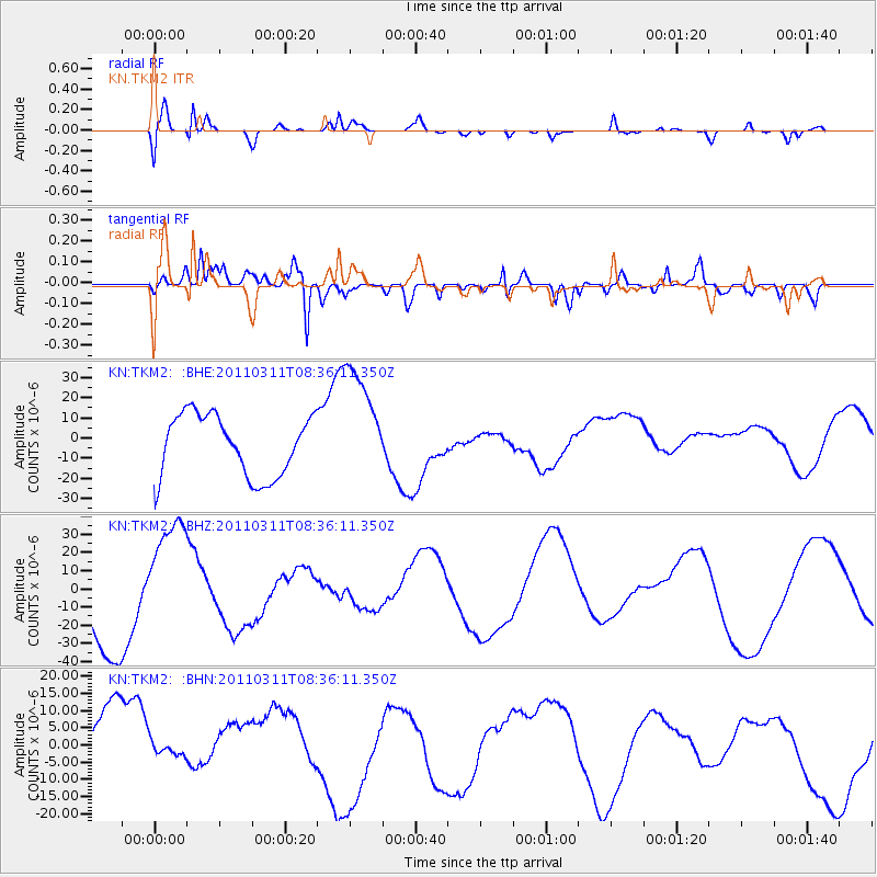
TKM2 KN.TKM2 - Earthquake Result Viewer
*The percent match for this event was below the threshold and hence no stack was calculated.
| Earthquake location: |
Near East Coast Of Honshu, Japan |
| Earthquake latitude/longitude: |
38.0/142.7 |
| Earthquake time(UTC): |
2011/03/11 (070) 08:27:51 GMT |
| Earthquake Depth: |
43 km |
| Earthquake Magnitude: |
6.0 MB |
| Earthquake Catalog/Contributor: |
WHDF/NEIC |
|
| Network: |
KN Kyrgyz Seismic Telemetry Network |
| Station: |
TKM2 KN.TKM2 |
| Lat/Lon: |
42.92 N/75.60 E |
| Elevation: |
2020 m |
|
| Distance: |
50.0 deg |
| Az: |
298.042 deg |
| Baz: |
71.622 deg |
| Ray Param: |
$rayparam |
*The percent match for this event was below the threshold and hence was not used in the summary stack. |
|
| Radial Match: |
77.75506 % |
| Radial Bump: |
350 |
| Transverse Match: |
64.98127 % |
| Transverse Bump: |
400 |
| SOD ConfigId: |
356183 |
| Insert Time: |
2011-08-13 12:33:24.430 +0000 |
| GWidth: |
2.5 |
| Max Bumps: |
400 |
| Tol: |
0.001 |
|
Signal To Noise
| Channel | StoN | STA | LTA |
| KN:TKM2: :BHZ:20110311T08:36:11.350Z | 1.4751108 | 3.4154204E-5 | 2.3153654E-5 |
| KN:TKM2: :BHN:20110311T08:36:11.350Z | 0.32515106 | 2.5328106E-6 | 7.789643E-6 |
| KN:TKM2: :BHE:20110311T08:36:11.350Z | 1.9223627 | 2.9180585E-5 | 1.5179541E-5 |
| Arrivals |
| Ps | |
| PpPs | |
| PsPs/PpSs | |


