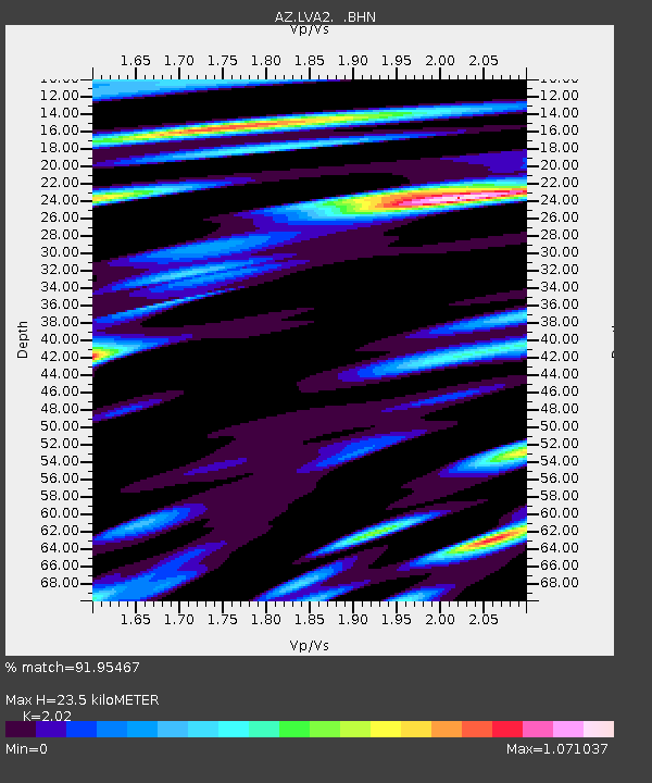
LVA2 AZ.LVA2 - Earthquake Result Viewer
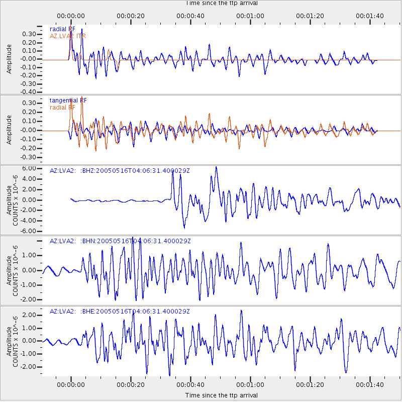
Earthquake location: South Of Kermadec Islands
Earthquake latitude/longitude: -32.6/-179.4
Earthquake time(UTC): 2005/05/16 (136) 03:54:14 GMT
Earthquake Depth: 34 km
Earthquake Magnitude: 6.2 MB, 6.4 MS, 6.6 MW, 6.6 MW
Earthquake Catalog/Contributor: WHDF/NEIC
Network: AZ ANZA Regional Network
Station: LVA2 AZ.LVA2
Lat/Lon: 33.35 N/116.56 W
Elevation: 1435 m
Distance: 88.3 deg
Az: 48.135 deg
Baz: 228.687 deg
Ray Param: 0.042648457
Estimated Moho Depth: 23.5 km
Estimated Crust Vp/Vs: 2.02
Assumed Crust Vp: 6.264 km/s
Estimated Crust Vs: 3.101 km/s
Estimated Crust Poisson's Ratio: 0.34
Radial Match: 91.95467 %
Radial Bump: 400
Transverse Match: 85.30575 %
Transverse Bump: 400
SOD ConfigId: 32974
Insert Time: 2010-02-26 19:46:08.379 +0000
GWidth: 2.5
Max Bumps: 400
Tol: 0.001

Signal To Noise

ChannelStoNSTALTA
AZ:LVA2: :BHN:20050516T04:06:31.400029Z1.8951652.7998055E-71.4773413E-7
AZ:LVA2: :BHE:20050516T04:06:31.400029Z1.08224022.4592208E-72.272343E-7
AZ:LVA2: :BHZ:20050516T04:06:31.400029Z13.7064731.6818333E-61.2270358E-7
Arrivals
Ps3.9 SECOND
PpPs11 SECOND
PsPs/PpSs15 SECOND