You are here: Home > Network List > TA - USArray Transportable Network (new EarthScope stations) Stations List
> Station 133A Hamilton Ranch, Breckenridge, TX, USA > Earthquake Result Viewer
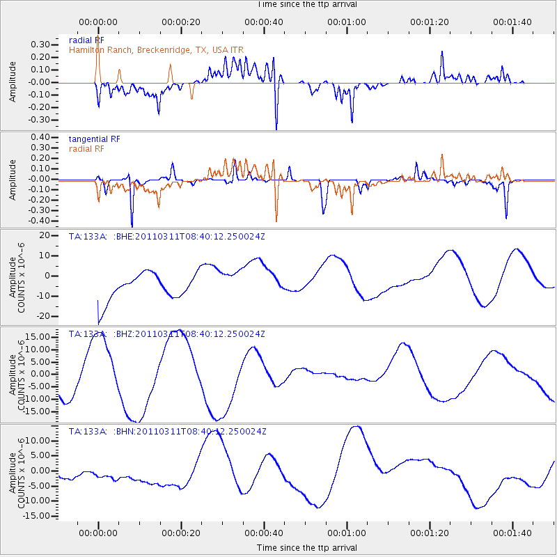
133A Hamilton Ranch, Breckenridge, TX, USA - Earthquake Result Viewer
*The percent match for this event was below the threshold and hence no stack was calculated.
| Earthquake location: |
Near East Coast Of Honshu, Japan |
| Earthquake latitude/longitude: |
38.0/142.7 |
| Earthquake time(UTC): |
2011/03/11 (070) 08:27:51 GMT |
| Earthquake Depth: |
43 km |
| Earthquake Magnitude: |
6.0 MB |
| Earthquake Catalog/Contributor: |
WHDF/NEIC |
|
| Network: |
TA USArray Transportable Network (new EarthScope stations) |
| Station: |
133A Hamilton Ranch, Breckenridge, TX, USA |
| Lat/Lon: |
32.61 N/98.92 W |
| Elevation: |
418 m |
|
| Distance: |
89.3 deg |
| Az: |
47.927 deg |
| Baz: |
316.001 deg |
| Ray Param: |
$rayparam |
*The percent match for this event was below the threshold and hence was not used in the summary stack. |
|
| Radial Match: |
78.73084 % |
| Radial Bump: |
320 |
| Transverse Match: |
66.036705 % |
| Transverse Bump: |
194 |
| SOD ConfigId: |
356183 |
| Insert Time: |
2011-08-13 13:02:51.963 +0000 |
| GWidth: |
2.5 |
| Max Bumps: |
400 |
| Tol: |
0.001 |
|
Signal To Noise
| Channel | StoN | STA | LTA |
| TA:133A: :BHZ:20110311T08:40:12.250024Z | 1.5370897 | 1.1927851E-5 | 7.7600225E-6 |
| TA:133A: :BHN:20110311T08:40:12.250024Z | 1.131905 | 3.6923436E-6 | 3.2620615E-6 |
| TA:133A: :BHE:20110311T08:40:12.250024Z | 1.0952772 | 7.088624E-6 | 6.471991E-6 |
| Arrivals |
| Ps | |
| PpPs | |
| PsPs/PpSs | |


