You are here: Home > Network List > TA - USArray Transportable Network (new EarthScope stations) Stations List
> Station 139A Bunkhouse Ranch, Marshall, TX, USA > Earthquake Result Viewer
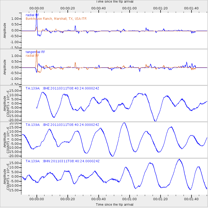
139A Bunkhouse Ranch, Marshall, TX, USA - Earthquake Result Viewer
*The percent match for this event was below the threshold and hence no stack was calculated.
| Earthquake location: |
Near East Coast Of Honshu, Japan |
| Earthquake latitude/longitude: |
38.0/142.7 |
| Earthquake time(UTC): |
2011/03/11 (070) 08:27:51 GMT |
| Earthquake Depth: |
43 km |
| Earthquake Magnitude: |
6.0 MB |
| Earthquake Catalog/Contributor: |
WHDF/NEIC |
|
| Network: |
TA USArray Transportable Network (new EarthScope stations) |
| Station: |
139A Bunkhouse Ranch, Marshall, TX, USA |
| Lat/Lon: |
32.68 N/94.39 W |
| Elevation: |
59 m |
|
| Distance: |
91.9 deg |
| Az: |
45.078 deg |
| Baz: |
318.461 deg |
| Ray Param: |
$rayparam |
*The percent match for this event was below the threshold and hence was not used in the summary stack. |
|
| Radial Match: |
74.76783 % |
| Radial Bump: |
400 |
| Transverse Match: |
58.759853 % |
| Transverse Bump: |
399 |
| SOD ConfigId: |
356183 |
| Insert Time: |
2011-08-13 13:10:20.912 +0000 |
| GWidth: |
2.5 |
| Max Bumps: |
400 |
| Tol: |
0.001 |
|
Signal To Noise
| Channel | StoN | STA | LTA |
| TA:139A: :BHZ:20110311T08:40:24.000024Z | 2.6052766 | 8.583769E-6 | 3.294763E-6 |
| TA:139A: :BHN:20110311T08:40:24.000024Z | 0.36409214 | 2.9688456E-6 | 8.154105E-6 |
| TA:139A: :BHE:20110311T08:40:24.000024Z | 0.6899111 | 6.3486095E-6 | 9.202068E-6 |
| Arrivals |
| Ps | |
| PpPs | |
| PsPs/PpSs | |


