You are here: Home > Network List > TA - USArray Transportable Network (new EarthScope stations) Stations List
> Station K34A Le Mars, IA, USA > Earthquake Result Viewer
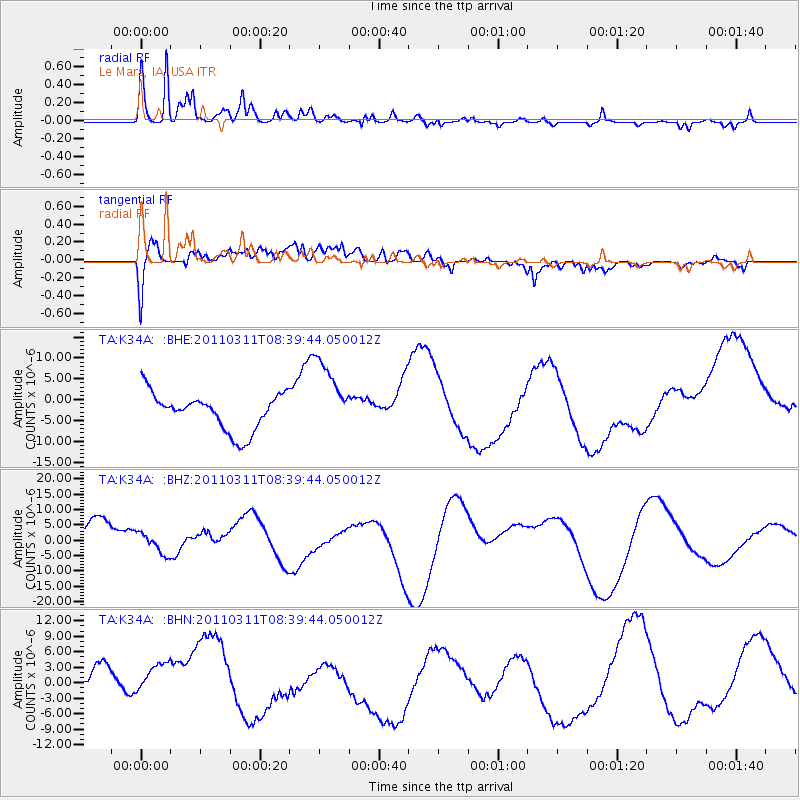
K34A Le Mars, IA, USA - Earthquake Result Viewer
*The percent match for this event was below the threshold and hence no stack was calculated.
| Earthquake location: |
Near East Coast Of Honshu, Japan |
| Earthquake latitude/longitude: |
38.0/142.7 |
| Earthquake time(UTC): |
2011/03/11 (070) 08:27:51 GMT |
| Earthquake Depth: |
43 km |
| Earthquake Magnitude: |
6.0 MB |
| Earthquake Catalog/Contributor: |
WHDF/NEIC |
|
| Network: |
TA USArray Transportable Network (new EarthScope stations) |
| Station: |
K34A Le Mars, IA, USA |
| Lat/Lon: |
42.69 N/96.10 W |
| Elevation: |
436 m |
|
| Distance: |
83.6 deg |
| Az: |
39.374 deg |
| Baz: |
317.192 deg |
| Ray Param: |
$rayparam |
*The percent match for this event was below the threshold and hence was not used in the summary stack. |
|
| Radial Match: |
79.88784 % |
| Radial Bump: |
400 |
| Transverse Match: |
58.269123 % |
| Transverse Bump: |
400 |
| SOD ConfigId: |
356183 |
| Insert Time: |
2011-08-13 13:16:29.148 +0000 |
| GWidth: |
2.5 |
| Max Bumps: |
400 |
| Tol: |
0.001 |
|
Signal To Noise
| Channel | StoN | STA | LTA |
| TA:K34A: :BHZ:20110311T08:39:44.050012Z | 0.37240946 | 3.2695318E-6 | 8.779401E-6 |
| TA:K34A: :BHN:20110311T08:39:44.050012Z | 0.80788714 | 6.320452E-6 | 7.823434E-6 |
| TA:K34A: :BHE:20110311T08:39:44.050012Z | 2.0146122 | 8.996782E-6 | 4.4657636E-6 |
| Arrivals |
| Ps | |
| PpPs | |
| PsPs/PpSs | |


