You are here: Home > Network List > TA - USArray Transportable Network (new EarthScope stations) Stations List
> Station V39A Pettigrew, AR, USA > Earthquake Result Viewer
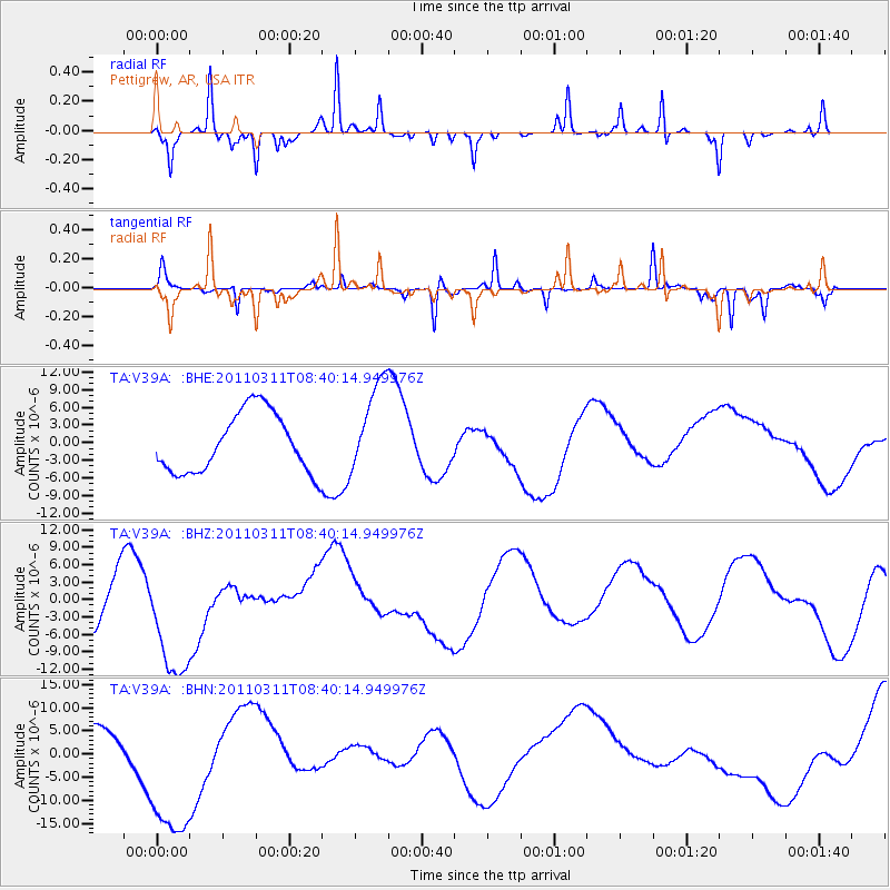
V39A Pettigrew, AR, USA - Earthquake Result Viewer
*The percent match for this event was below the threshold and hence no stack was calculated.
| Earthquake location: |
Near East Coast Of Honshu, Japan |
| Earthquake latitude/longitude: |
38.0/142.7 |
| Earthquake time(UTC): |
2011/03/11 (070) 08:27:51 GMT |
| Earthquake Depth: |
43 km |
| Earthquake Magnitude: |
6.0 MB |
| Earthquake Catalog/Contributor: |
WHDF/NEIC |
|
| Network: |
TA USArray Transportable Network (new EarthScope stations) |
| Station: |
V39A Pettigrew, AR, USA |
| Lat/Lon: |
35.84 N/93.64 W |
| Elevation: |
744 m |
|
| Distance: |
89.9 deg |
| Az: |
42.532 deg |
| Baz: |
318.92 deg |
| Ray Param: |
$rayparam |
*The percent match for this event was below the threshold and hence was not used in the summary stack. |
|
| Radial Match: |
82.51101 % |
| Radial Bump: |
211 |
| Transverse Match: |
78.83877 % |
| Transverse Bump: |
218 |
| SOD ConfigId: |
356183 |
| Insert Time: |
2011-08-13 13:29:28.739 +0000 |
| GWidth: |
2.5 |
| Max Bumps: |
400 |
| Tol: |
0.001 |
|
Signal To Noise
| Channel | StoN | STA | LTA |
| TA:V39A: :BHZ:20110311T08:40:14.949976Z | 1.4599758 | 1.3128217E-5 | 8.992079E-6 |
| TA:V39A: :BHN:20110311T08:40:14.949976Z | 5.24904 | 1.8891868E-5 | 3.599109E-6 |
| TA:V39A: :BHE:20110311T08:40:14.949976Z | 1.5559193 | 7.888161E-6 | 5.0697754E-6 |
| Arrivals |
| Ps | |
| PpPs | |
| PsPs/PpSs | |


