You are here: Home > Network List > TA - USArray Transportable Network (new EarthScope stations) Stations List
> Station S29A Ulysses, KS, USA > Earthquake Result Viewer
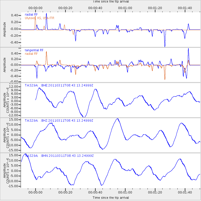
S29A Ulysses, KS, USA - Earthquake Result Viewer
*The percent match for this event was below the threshold and hence no stack was calculated.
| Earthquake location: |
Near East Coast Of Honshu, Japan |
| Earthquake latitude/longitude: |
37.5/141.2 |
| Earthquake time(UTC): |
2011/03/11 (070) 08:31:09 GMT |
| Earthquake Depth: |
37 km |
| Earthquake Magnitude: |
6.0 MB |
| Earthquake Catalog/Contributor: |
WHDF/NEIC |
|
| Network: |
TA USArray Transportable Network (new EarthScope stations) |
| Station: |
S29A Ulysses, KS, USA |
| Lat/Lon: |
37.62 N/101.12 W |
| Elevation: |
931 m |
|
| Distance: |
85.7 deg |
| Az: |
44.827 deg |
| Baz: |
315.058 deg |
| Ray Param: |
$rayparam |
*The percent match for this event was below the threshold and hence was not used in the summary stack. |
|
| Radial Match: |
49.81352 % |
| Radial Bump: |
227 |
| Transverse Match: |
47.910767 % |
| Transverse Bump: |
400 |
| SOD ConfigId: |
356183 |
| Insert Time: |
2011-08-13 14:37:58.519 +0000 |
| GWidth: |
2.5 |
| Max Bumps: |
400 |
| Tol: |
0.001 |
|
Signal To Noise
| Channel | StoN | STA | LTA |
| TA:S29A: :BHZ:20110311T08:43:13.24999Z | 1.1875675 | 3.828014E-6 | 3.2234077E-6 |
| TA:S29A: :BHN:20110311T08:43:13.24999Z | 1.1490175 | 8.442778E-6 | 7.347825E-6 |
| TA:S29A: :BHE:20110311T08:43:13.24999Z | 2.9489589 | 1.4358444E-5 | 4.8689876E-6 |
| Arrivals |
| Ps | |
| PpPs | |
| PsPs/PpSs | |


