You are here: Home > Network List > TA - USArray Transportable Network (new EarthScope stations) Stations List
> Station V38A Canehill, AR, USA > Earthquake Result Viewer
V38A Canehill, AR, USA - Earthquake Result Viewer
*The percent match for this event was below the threshold and hence no stack was calculated.
| Earthquake location: |
Near East Coast Of Honshu, Japan |
| Earthquake latitude/longitude: |
37.5/141.2 |
| Earthquake time(UTC): |
2011/03/11 (070) 08:31:09 GMT |
| Earthquake Depth: |
37 km |
| Earthquake Magnitude: |
6.0 MB |
| Earthquake Catalog/Contributor: |
WHDF/NEIC |
|
| Network: |
TA USArray Transportable Network (new EarthScope stations) |
| Station: |
V38A Canehill, AR, USA |
| Lat/Lon: |
35.86 N/94.41 W |
| Elevation: |
372 m |
|
| Distance: |
90.7 deg |
| Az: |
42.078 deg |
| Baz: |
318.973 deg |
| Ray Param: |
$rayparam |
*The percent match for this event was below the threshold and hence was not used in the summary stack. |
|
| Radial Match: |
52.90056 % |
| Radial Bump: |
350 |
| Transverse Match: |
71.481575 % |
| Transverse Bump: |
266 |
| SOD ConfigId: |
356183 |
| Insert Time: |
2011-08-13 15:01:14.148 +0000 |
| GWidth: |
2.5 |
| Max Bumps: |
400 |
| Tol: |
0.001 |
|
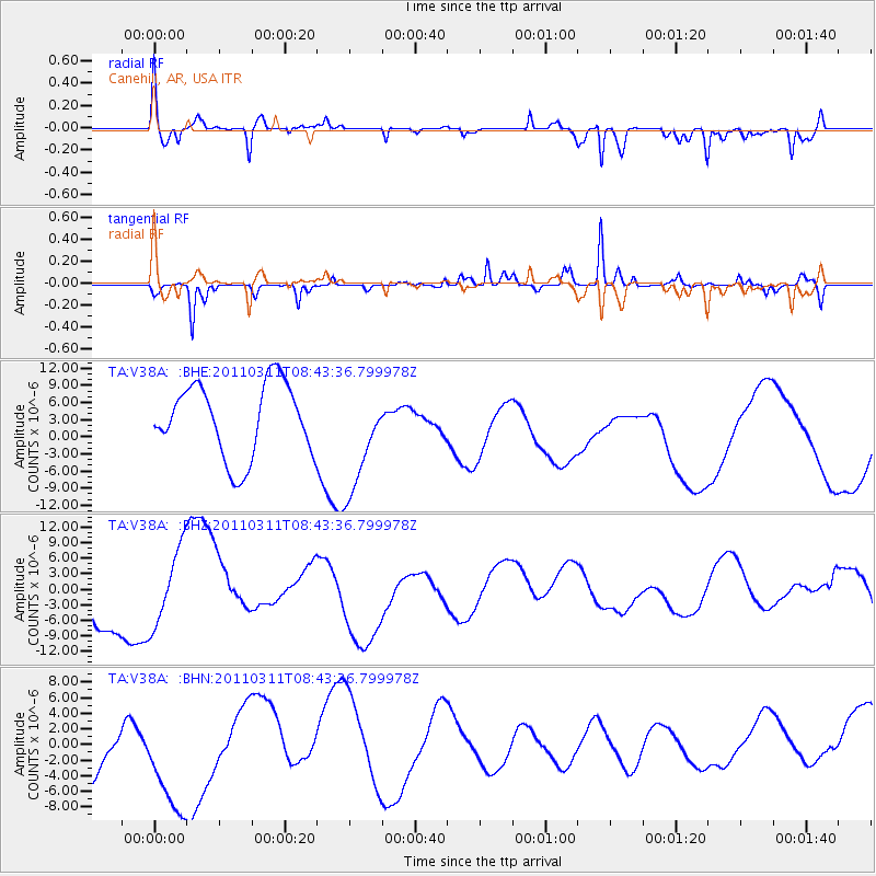
Signal To Noise
| Channel | StoN | STA | LTA |
| TA:V38A: :BHZ:20110311T08:43:36.799978Z | 0.98420596 | 7.366203E-6 | 7.484412E-6 |
| TA:V38A: :BHN:20110311T08:43:36.799978Z | 1.8607695 | 7.950701E-6 | 4.2728025E-6 |
| TA:V38A: :BHE:20110311T08:43:36.799978Z | 1.4807537 | 9.457862E-6 | 6.3871944E-6 |
| Arrivals |
| Ps | |
| PpPs | |
| PsPs/PpSs | |


