You are here: Home > Network List > TA - USArray Transportable Network (new EarthScope stations) Stations List
> Station D36A Goodland, MN, USA > Earthquake Result Viewer
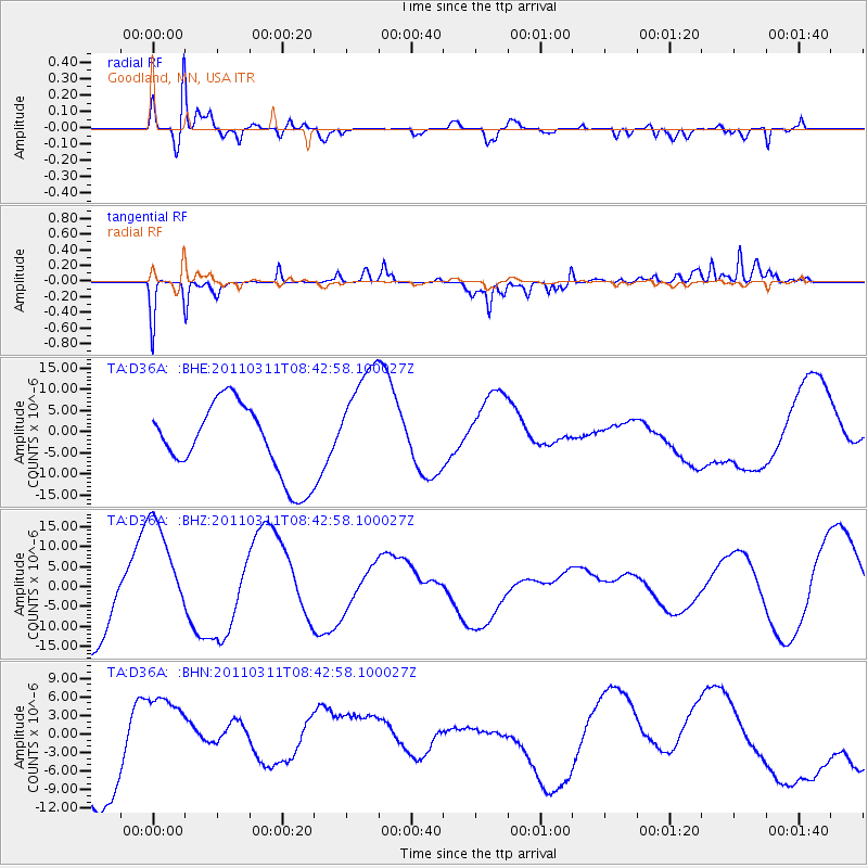
D36A Goodland, MN, USA - Earthquake Result Viewer
*The percent match for this event was below the threshold and hence no stack was calculated.
| Earthquake location: |
Near East Coast Of Honshu, Japan |
| Earthquake latitude/longitude: |
37.5/141.2 |
| Earthquake time(UTC): |
2011/03/11 (070) 08:31:09 GMT |
| Earthquake Depth: |
37 km |
| Earthquake Magnitude: |
6.0 MB |
| Earthquake Catalog/Contributor: |
WHDF/NEIC |
|
| Network: |
TA USArray Transportable Network (new EarthScope stations) |
| Station: |
D36A Goodland, MN, USA |
| Lat/Lon: |
47.18 N/93.16 W |
| Elevation: |
434 m |
|
| Distance: |
82.7 deg |
| Az: |
33.971 deg |
| Baz: |
319.33 deg |
| Ray Param: |
$rayparam |
*The percent match for this event was below the threshold and hence was not used in the summary stack. |
|
| Radial Match: |
76.88932 % |
| Radial Bump: |
396 |
| Transverse Match: |
64.58058 % |
| Transverse Bump: |
276 |
| SOD ConfigId: |
356183 |
| Insert Time: |
2011-08-13 15:06:20.084 +0000 |
| GWidth: |
2.5 |
| Max Bumps: |
400 |
| Tol: |
0.001 |
|
Signal To Noise
| Channel | StoN | STA | LTA |
| TA:D36A: :BHZ:20110311T08:42:58.100027Z | 1.5566586 | 1.28742E-5 | 8.270406E-6 |
| TA:D36A: :BHN:20110311T08:42:58.100027Z | 1.1291871 | 8.462021E-6 | 7.4939053E-6 |
| TA:D36A: :BHE:20110311T08:42:58.100027Z | 1.5993043 | 1.3643465E-5 | 8.530875E-6 |
| Arrivals |
| Ps | |
| PpPs | |
| PsPs/PpSs | |


