You are here: Home > Network List > TA - USArray Transportable Network (new EarthScope stations) Stations List
> Station F31A Hecla, SD, USA > Earthquake Result Viewer
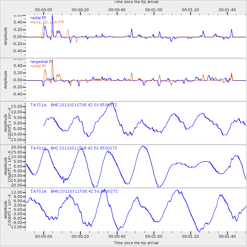
F31A Hecla, SD, USA - Earthquake Result Viewer
*The percent match for this event was below the threshold and hence no stack was calculated.
| Earthquake location: |
Near East Coast Of Honshu, Japan |
| Earthquake latitude/longitude: |
37.5/141.2 |
| Earthquake time(UTC): |
2011/03/11 (070) 08:31:09 GMT |
| Earthquake Depth: |
37 km |
| Earthquake Magnitude: |
6.0 MB |
| Earthquake Catalog/Contributor: |
WHDF/NEIC |
|
| Network: |
TA USArray Transportable Network (new EarthScope stations) |
| Station: |
F31A Hecla, SD, USA |
| Lat/Lon: |
45.86 N/98.25 W |
| Elevation: |
412 m |
|
| Distance: |
81.3 deg |
| Az: |
37.489 deg |
| Baz: |
316.136 deg |
| Ray Param: |
$rayparam |
*The percent match for this event was below the threshold and hence was not used in the summary stack. |
|
| Radial Match: |
68.95741 % |
| Radial Bump: |
329 |
| Transverse Match: |
36.91277 % |
| Transverse Bump: |
400 |
| SOD ConfigId: |
356183 |
| Insert Time: |
2011-08-13 15:06:42.681 +0000 |
| GWidth: |
2.5 |
| Max Bumps: |
400 |
| Tol: |
0.001 |
|
Signal To Noise
| Channel | StoN | STA | LTA |
| TA:F31A: :BHZ:20110311T08:42:50.850027Z | 3.846678 | 1.7627377E-5 | 4.5824936E-6 |
| TA:F31A: :BHN:20110311T08:42:50.850027Z | 0.5643921 | 2.8563436E-6 | 5.0609206E-6 |
| TA:F31A: :BHE:20110311T08:42:50.850027Z | 1.7479658 | 9.15116E-6 | 5.2353203E-6 |
| Arrivals |
| Ps | |
| PpPs | |
| PsPs/PpSs | |


