You are here: Home > Network List > TA - USArray Transportable Network (new EarthScope stations) Stations List
> Station W40A Ferguson Farm, Pottsville, AR, USA > Earthquake Result Viewer
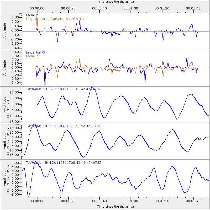
W40A Ferguson Farm, Pottsville, AR, USA - Earthquake Result Viewer
*The percent match for this event was below the threshold and hence no stack was calculated.
| Earthquake location: |
Near East Coast Of Honshu, Japan |
| Earthquake latitude/longitude: |
37.5/141.2 |
| Earthquake time(UTC): |
2011/03/11 (070) 08:31:09 GMT |
| Earthquake Depth: |
37 km |
| Earthquake Magnitude: |
6.0 MB |
| Earthquake Catalog/Contributor: |
WHDF/NEIC |
|
| Network: |
TA USArray Transportable Network (new EarthScope stations) |
| Station: |
W40A Ferguson Farm, Pottsville, AR, USA |
| Lat/Lon: |
35.19 N/93.07 W |
| Elevation: |
108 m |
|
| Distance: |
91.9 deg |
| Az: |
41.685 deg |
| Baz: |
319.756 deg |
| Ray Param: |
$rayparam |
*The percent match for this event was below the threshold and hence was not used in the summary stack. |
|
| Radial Match: |
52.056076 % |
| Radial Bump: |
400 |
| Transverse Match: |
62.49801 % |
| Transverse Bump: |
354 |
| SOD ConfigId: |
356183 |
| Insert Time: |
2011-08-13 15:13:08.538 +0000 |
| GWidth: |
2.5 |
| Max Bumps: |
400 |
| Tol: |
0.001 |
|
Signal To Noise
| Channel | StoN | STA | LTA |
| TA:W40A: :BHZ:20110311T08:43:42.424978Z | 1.4568574 | 1.2491736E-5 | 8.57444E-6 |
| TA:W40A: :BHN:20110311T08:43:42.424978Z | 1.4779158 | 1.0439854E-5 | 7.0639035E-6 |
| TA:W40A: :BHE:20110311T08:43:42.424978Z | 1.386124 | 7.561608E-6 | 5.4552174E-6 |
| Arrivals |
| Ps | |
| PpPs | |
| PsPs/PpSs | |


