You are here: Home > Network List > CI - Caltech Regional Seismic Network Stations List
> Station MPM Manuel Prospect Mine, California, USA > Earthquake Result Viewer
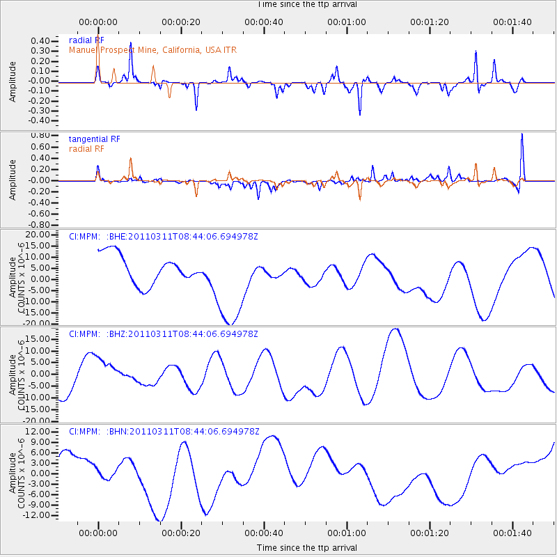
MPM Manuel Prospect Mine, California, USA - Earthquake Result Viewer
*The percent match for this event was below the threshold and hence no stack was calculated.
| Earthquake location: |
Near East Coast Of Honshu, Japan |
| Earthquake latitude/longitude: |
39.1/143.0 |
| Earthquake time(UTC): |
2011/03/11 (070) 08:33:00 GMT |
| Earthquake Depth: |
28 km |
| Earthquake Magnitude: |
6.0 MB |
| Earthquake Catalog/Contributor: |
WHDF/NEIC |
|
| Network: |
CI Caltech Regional Seismic Network |
| Station: |
MPM Manuel Prospect Mine, California, USA |
| Lat/Lon: |
36.06 N/117.49 W |
| Elevation: |
185 m |
|
| Distance: |
74.7 deg |
| Az: |
55.94 deg |
| Baz: |
307.335 deg |
| Ray Param: |
$rayparam |
*The percent match for this event was below the threshold and hence was not used in the summary stack. |
|
| Radial Match: |
50.627075 % |
| Radial Bump: |
294 |
| Transverse Match: |
60.632717 % |
| Transverse Bump: |
326 |
| SOD ConfigId: |
356183 |
| Insert Time: |
2011-08-13 15:41:44.283 +0000 |
| GWidth: |
2.5 |
| Max Bumps: |
400 |
| Tol: |
0.001 |
|
Signal To Noise
| Channel | StoN | STA | LTA |
| CI:MPM: :BHZ:20110311T08:44:06.694978Z | 0.6907057 | 8.0644E-6 | 1.16755955E-5 |
| CI:MPM: :BHN:20110311T08:44:06.694978Z | 0.3349832 | 1.7253469E-6 | 5.1505476E-6 |
| CI:MPM: :BHE:20110311T08:44:06.694978Z | 3.3719754 | 2.1796173E-5 | 6.463918E-6 |
| Arrivals |
| Ps | |
| PpPs | |
| PsPs/PpSs | |


