You are here: Home > Network List > CN - Canadian National Seismograph Network Stations List
> Station INK INUVIK, NT, CANADA.ANADA > Earthquake Result Viewer
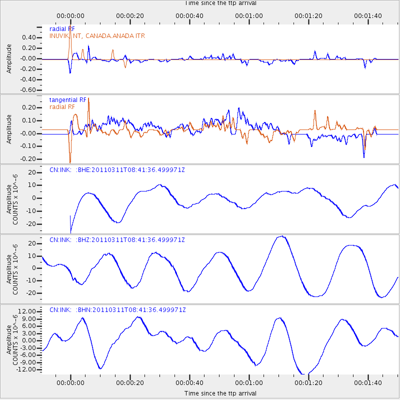
INK INUVIK, NT, CANADA.ANADA - Earthquake Result Viewer
*The percent match for this event was below the threshold and hence no stack was calculated.
| Earthquake location: |
Near East Coast Of Honshu, Japan |
| Earthquake latitude/longitude: |
39.1/143.0 |
| Earthquake time(UTC): |
2011/03/11 (070) 08:33:00 GMT |
| Earthquake Depth: |
28 km |
| Earthquake Magnitude: |
6.0 MB |
| Earthquake Catalog/Contributor: |
WHDF/NEIC |
|
| Network: |
CN Canadian National Seismograph Network |
| Station: |
INK INUVIK, NT, CANADA.ANADA |
| Lat/Lon: |
68.31 N/133.52 W |
| Elevation: |
40 m |
|
| Distance: |
52.0 deg |
| Az: |
27.974 deg |
| Baz: |
281.141 deg |
| Ray Param: |
$rayparam |
*The percent match for this event was below the threshold and hence was not used in the summary stack. |
|
| Radial Match: |
69.96029 % |
| Radial Bump: |
348 |
| Transverse Match: |
43.405117 % |
| Transverse Bump: |
400 |
| SOD ConfigId: |
356183 |
| Insert Time: |
2011-08-13 15:46:29.465 +0000 |
| GWidth: |
2.5 |
| Max Bumps: |
400 |
| Tol: |
0.001 |
|
Signal To Noise
| Channel | StoN | STA | LTA |
| CN:INK: :BHZ:20110311T08:41:36.499971Z | 0.5621242 | 9.986817E-6 | 1.7766211E-5 |
| CN:INK: :BHN:20110311T08:41:36.499971Z | 1.3459334 | 1.5449084E-5 | 1.14783425E-5 |
| CN:INK: :BHE:20110311T08:41:36.499971Z | 1.5329664 | 1.3361588E-5 | 8.716165E-6 |
| Arrivals |
| Ps | |
| PpPs | |
| PsPs/PpSs | |


