You are here: Home > Network List > TA - USArray Transportable Network (new EarthScope stations) Stations List
> Station Q34A Chapman, KS, USA > Earthquake Result Viewer
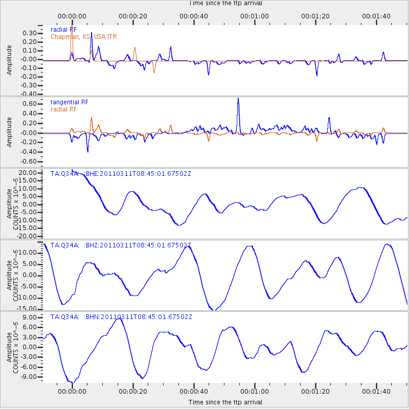
Q34A Chapman, KS, USA - Earthquake Result Viewer
*The percent match for this event was below the threshold and hence no stack was calculated.
| Earthquake location: |
Near East Coast Of Honshu, Japan |
| Earthquake latitude/longitude: |
39.1/143.0 |
| Earthquake time(UTC): |
2011/03/11 (070) 08:33:00 GMT |
| Earthquake Depth: |
28 km |
| Earthquake Magnitude: |
6.0 MB |
| Earthquake Catalog/Contributor: |
WHDF/NEIC |
|
| Network: |
TA USArray Transportable Network (new EarthScope stations) |
| Station: |
Q34A Chapman, KS, USA |
| Lat/Lon: |
38.92 N/96.94 W |
| Elevation: |
378 m |
|
| Distance: |
84.9 deg |
| Az: |
42.659 deg |
| Baz: |
317.503 deg |
| Ray Param: |
$rayparam |
*The percent match for this event was below the threshold and hence was not used in the summary stack. |
|
| Radial Match: |
71.43525 % |
| Radial Bump: |
308 |
| Transverse Match: |
59.29653 % |
| Transverse Bump: |
400 |
| SOD ConfigId: |
356183 |
| Insert Time: |
2011-08-13 16:27:13.114 +0000 |
| GWidth: |
2.5 |
| Max Bumps: |
400 |
| Tol: |
0.001 |
|
Signal To Noise
| Channel | StoN | STA | LTA |
| TA:Q34A: :BHZ:20110311T08:45:01.67502Z | 0.92332566 | 7.124255E-6 | 7.715864E-6 |
| TA:Q34A: :BHN:20110311T08:45:01.67502Z | 2.0095615 | 1.240608E-5 | 6.173526E-6 |
| TA:Q34A: :BHE:20110311T08:45:01.67502Z | 1.5730324 | 1.3551434E-5 | 8.6148475E-6 |
| Arrivals |
| Ps | |
| PpPs | |
| PsPs/PpSs | |


