You are here: Home > Network List > TA - USArray Transportable Network (new EarthScope stations) Stations List
> Station K32A Verdigre, NE, USA > Earthquake Result Viewer
K32A Verdigre, NE, USA - Earthquake Result Viewer
| Earthquake location: |
Near East Coast Of Honshu, Japan |
| Earthquake latitude/longitude: |
39.1/143.0 |
| Earthquake time(UTC): |
2011/03/11 (070) 08:33:00 GMT |
| Earthquake Depth: |
28 km |
| Earthquake Magnitude: |
6.0 MB |
| Earthquake Catalog/Contributor: |
WHDF/NEIC |
|
| Network: |
TA USArray Transportable Network (new EarthScope stations) |
| Station: |
K32A Verdigre, NE, USA |
| Lat/Lon: |
42.66 N/97.97 W |
| Elevation: |
512 m |
|
| Distance: |
81.6 deg |
| Az: |
40.674 deg |
| Baz: |
316.598 deg |
| Ray Param: |
0.047428023 |
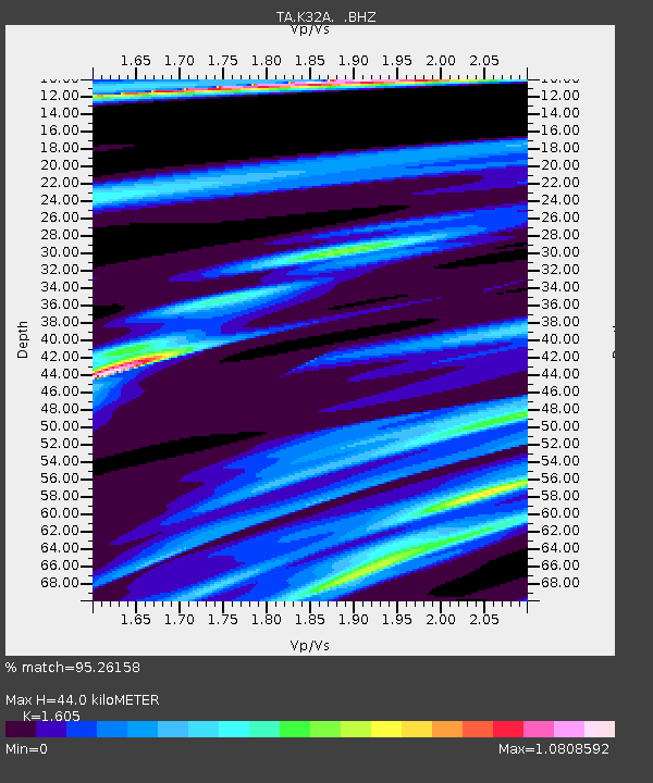
| Estimated Moho Depth: |
44.0 km |
| Estimated Crust Vp/Vs: |
1.61 |
| Assumed Crust Vp: |
6.498 km/s |
| Estimated Crust Vs: |
4.048 km/s |
| Estimated Crust Poisson's Ratio: |
0.18 |
|
| Radial Match: |
95.26158 % |
| Radial Bump: |
400 |
| Transverse Match: |
66.1589 % |
| Transverse Bump: |
400 |
| SOD ConfigId: |
356183 |
| Insert Time: |
2011-08-13 16:32:29.652 +0000 |
| GWidth: |
2.5 |
| Max Bumps: |
400 |
| Tol: |
0.001 |
|

Signal To Noise
| Channel | StoN | STA | LTA |
| TA:K32A: :BHZ:20110311T08:44:44.899995Z | 0.87826794 | 1.6347853E-5 | 1.8613742E-5 |
| TA:K32A: :BHN:20110311T08:44:44.899995Z | 0.17321324 | 1.5322926E-6 | 8.846278E-6 |
| TA:K32A: :BHE:20110311T08:44:44.899995Z | 3.872653 | 1.8523282E-5 | 4.783099E-6 |
| Arrivals |
| Ps | 4.2 SECOND |
| PpPs | 17 SECOND |
| PsPs/PpSs | 21 SECOND |


