You are here: Home > Network List > TA - USArray Transportable Network (new EarthScope stations) Stations List
> Station D36A Goodland, MN, USA > Earthquake Result Viewer
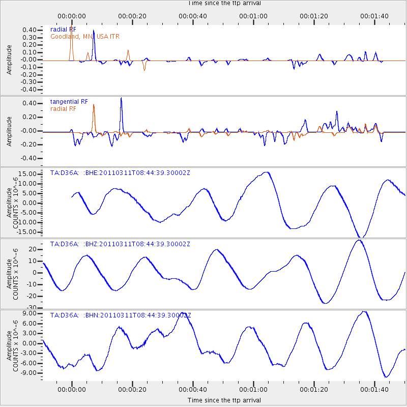
D36A Goodland, MN, USA - Earthquake Result Viewer
*The percent match for this event was below the threshold and hence no stack was calculated.
| Earthquake location: |
Near East Coast Of Honshu, Japan |
| Earthquake latitude/longitude: |
39.1/143.0 |
| Earthquake time(UTC): |
2011/03/11 (070) 08:33:00 GMT |
| Earthquake Depth: |
28 km |
| Earthquake Magnitude: |
6.0 MB |
| Earthquake Catalog/Contributor: |
WHDF/NEIC |
|
| Network: |
TA USArray Transportable Network (new EarthScope stations) |
| Station: |
D36A Goodland, MN, USA |
| Lat/Lon: |
47.18 N/93.16 W |
| Elevation: |
434 m |
|
| Distance: |
80.6 deg |
| Az: |
35.045 deg |
| Baz: |
319.112 deg |
| Ray Param: |
$rayparam |
*The percent match for this event was below the threshold and hence was not used in the summary stack. |
|
| Radial Match: |
68.079735 % |
| Radial Bump: |
259 |
| Transverse Match: |
58.77237 % |
| Transverse Bump: |
388 |
| SOD ConfigId: |
356183 |
| Insert Time: |
2011-08-13 16:37:14.098 +0000 |
| GWidth: |
2.5 |
| Max Bumps: |
400 |
| Tol: |
0.001 |
|
Signal To Noise
| Channel | StoN | STA | LTA |
| TA:D36A: :BHZ:20110311T08:44:39.30002Z | 1.8143522 | 9.431391E-6 | 5.198214E-6 |
| TA:D36A: :BHN:20110311T08:44:39.30002Z | 1.8694681 | 7.768487E-6 | 4.155453E-6 |
| TA:D36A: :BHE:20110311T08:44:39.30002Z | 2.2369847 | 9.557015E-6 | 4.2722754E-6 |
| Arrivals |
| Ps | |
| PpPs | |
| PsPs/PpSs | |


