You are here: Home > Network List > AZ - ANZA Regional Network Stations List
> Station LVA2 AZ.LVA2 > Earthquake Result Viewer
LVA2 AZ.LVA2 - Earthquake Result Viewer
| Earthquake location: |
Fiji Islands Region |
| Earthquake latitude/longitude: |
-20.9/-179.2 |
| Earthquake time(UTC): |
1995/01/17 (017) 16:54:12 GMT |
| Earthquake Depth: |
637 km |
| Earthquake Magnitude: |
6.0 MB, 6.2 UNKNOWN, 6.4 MW |
| Earthquake Catalog/Contributor: |
WHDF/NEIC |
|
| Network: |
AZ ANZA Regional Network |
| Station: |
LVA2 AZ.LVA2 |
| Lat/Lon: |
33.35 N/116.56 W |
| Elevation: |
1435 m |
|
| Distance: |
80.5 deg |
| Az: |
48.933 deg |
| Baz: |
237.393 deg |
| Ray Param: |
0.046262942 |
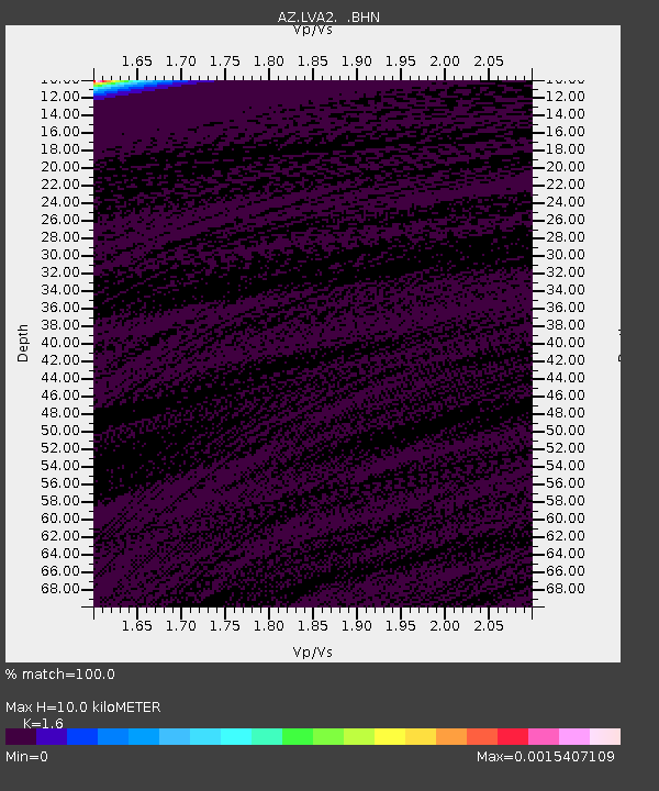
| Estimated Moho Depth: |
10.0 km |
| Estimated Crust Vp/Vs: |
1.60 |
| Assumed Crust Vp: |
6.264 km/s |
| Estimated Crust Vs: |
3.915 km/s |
| Estimated Crust Poisson's Ratio: |
0.18 |
|
| Radial Match: |
100.0 % |
| Radial Bump: |
2 |
| Transverse Match: |
100.0 % |
| Transverse Bump: |
2 |
| SOD ConfigId: |
6273 |
| Insert Time: |
2010-02-26 19:47:38.809 +0000 |
| GWidth: |
2.5 |
| Max Bumps: |
400 |
| Tol: |
0.001 |
|

Signal To Noise
| Channel | StoN | STA | LTA |
| AZ:LVA2: :BHN:19950117T17:04:48.250Z | 1.0615695 | 0.0018601115 | 0.0017522277 |
| AZ:LVA2: :BHE:19950117T17:04:48.250Z | 1.0614727 | 0.0018600216 | 0.0017523029 |
| AZ:LVA2: :BHZ:19950117T17:04:48.250Z | 1.0618869 | 0.0018607181 | 0.0017522752 |
| Arrivals |
| Ps | 1.0 SECOND |
| PpPs | 4.0 SECOND |
| PsPs/PpSs | 5.0 SECOND |


