You are here: Home > Network List > IC - New China Digital Seismograph Network Stations List
> Station KMI Kunming, Yunnan Province, China > Earthquake Result Viewer
KMI Kunming, Yunnan Province, China - Earthquake Result Viewer
| Earthquake location: |
Near East Coast Of Honshu, Japan |
| Earthquake latitude/longitude: |
36.0/141.0 |
| Earthquake time(UTC): |
2011/03/11 (070) 08:35:22 GMT |
| Earthquake Depth: |
20 km |
| Earthquake Magnitude: |
5.6 MB |
| Earthquake Catalog/Contributor: |
WHDF/NEIC |
|
| Network: |
IC New China Digital Seismograph Network |
| Station: |
KMI Kunming, Yunnan Province, China |
| Lat/Lon: |
25.12 N/102.74 E |
| Elevation: |
1975 m |
|
| Distance: |
34.5 deg |
| Az: |
262.415 deg |
| Baz: |
62.418 deg |
| Ray Param: |
0.07769851 |
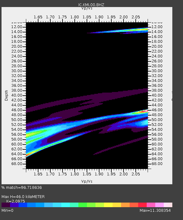
| Estimated Moho Depth: |
46.0 km |
| Estimated Crust Vp/Vs: |
2.10 |
| Assumed Crust Vp: |
6.247 km/s |
| Estimated Crust Vs: |
2.978 km/s |
| Estimated Crust Poisson's Ratio: |
0.35 |
|
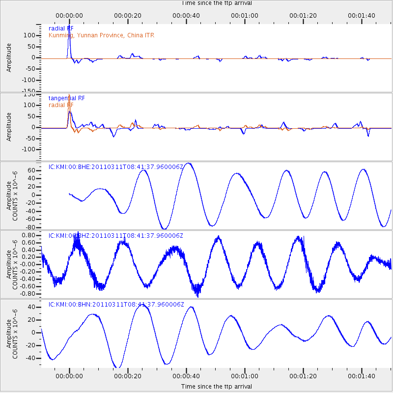
| Radial Match: |
96.718636 % |
| Radial Bump: |
258 |
| Transverse Match: |
59.152676 % |
| Transverse Bump: |
400 |
| SOD ConfigId: |
356183 |
| Insert Time: |
2011-08-13 17:32:52.360 +0000 |
| GWidth: |
2.5 |
| Max Bumps: |
400 |
| Tol: |
0.001 |
|
Signal To Noise
| Channel | StoN | STA | LTA |
| IC:KMI:00:BHZ:20110311T08:41:37.960006Z | 2.6510859 | 4.593335E-7 | 1.732624E-7 |
| IC:KMI:00:BHN:20110311T08:41:37.960006Z | 0.22720788 | 8.773695E-6 | 3.8615275E-5 |
| IC:KMI:00:BHE:20110311T08:41:37.960006Z | 2.7087963 | 6.4248314E-5 | 2.3718401E-5 |
| Arrivals |
| Ps | 8.6 SECOND |
| PpPs | 21 SECOND |
| PsPs/PpSs | 30 SECOND |


