You are here: Home > Network List > KN - Kyrgyz Seismic Telemetry Network Stations List
> Station TKM2 KN.TKM2 > Earthquake Result Viewer
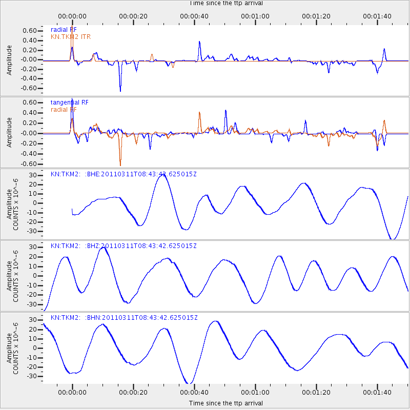
TKM2 KN.TKM2 - Earthquake Result Viewer
*The percent match for this event was below the threshold and hence no stack was calculated.
| Earthquake location: |
Near East Coast Of Honshu, Japan |
| Earthquake latitude/longitude: |
36.0/141.0 |
| Earthquake time(UTC): |
2011/03/11 (070) 08:35:22 GMT |
| Earthquake Depth: |
20 km |
| Earthquake Magnitude: |
5.6 MB |
| Earthquake Catalog/Contributor: |
WHDF/NEIC |
|
| Network: |
KN Kyrgyz Seismic Telemetry Network |
| Station: |
TKM2 KN.TKM2 |
| Lat/Lon: |
42.92 N/75.60 E |
| Elevation: |
2020 m |
|
| Distance: |
49.8 deg |
| Az: |
299.041 deg |
| Baz: |
74.732 deg |
| Ray Param: |
$rayparam |
*The percent match for this event was below the threshold and hence was not used in the summary stack. |
|
| Radial Match: |
83.10366 % |
| Radial Bump: |
400 |
| Transverse Match: |
41.428715 % |
| Transverse Bump: |
319 |
| SOD ConfigId: |
356183 |
| Insert Time: |
2011-08-13 17:39:17.966 +0000 |
| GWidth: |
2.5 |
| Max Bumps: |
400 |
| Tol: |
0.001 |
|
Signal To Noise
| Channel | StoN | STA | LTA |
| KN:TKM2: :BHZ:20110311T08:43:42.625015Z | 0.677128 | 1.0779897E-5 | 1.5920028E-5 |
| KN:TKM2: :BHN:20110311T08:43:42.625015Z | 1.9205287 | 2.7263932E-5 | 1.4196056E-5 |
| KN:TKM2: :BHE:20110311T08:43:42.625015Z | 2.490363 | 2.4253428E-5 | 9.738913E-6 |
| Arrivals |
| Ps | |
| PpPs | |
| PsPs/PpSs | |


