You are here: Home > Network List > TA - USArray Transportable Network (new EarthScope stations) Stations List
> Station S29A Ulysses, KS, USA > Earthquake Result Viewer
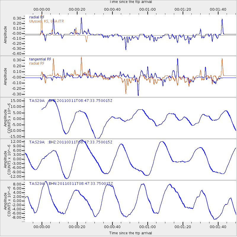
S29A Ulysses, KS, USA - Earthquake Result Viewer
*The percent match for this event was below the threshold and hence no stack was calculated.
| Earthquake location: |
Near East Coast Of Honshu, Japan |
| Earthquake latitude/longitude: |
36.0/141.0 |
| Earthquake time(UTC): |
2011/03/11 (070) 08:35:22 GMT |
| Earthquake Depth: |
20 km |
| Earthquake Magnitude: |
5.6 MB |
| Earthquake Catalog/Contributor: |
WHDF/NEIC |
|
| Network: |
TA USArray Transportable Network (new EarthScope stations) |
| Station: |
S29A Ulysses, KS, USA |
| Lat/Lon: |
37.62 N/101.12 W |
| Elevation: |
931 m |
|
| Distance: |
86.9 deg |
| Az: |
44.654 deg |
| Baz: |
314.157 deg |
| Ray Param: |
$rayparam |
*The percent match for this event was below the threshold and hence was not used in the summary stack. |
|
| Radial Match: |
58.336002 % |
| Radial Bump: |
400 |
| Transverse Match: |
61.32562 % |
| Transverse Bump: |
400 |
| SOD ConfigId: |
356183 |
| Insert Time: |
2011-08-13 17:54:02.138 +0000 |
| GWidth: |
2.5 |
| Max Bumps: |
400 |
| Tol: |
0.001 |
|
Signal To Noise
| Channel | StoN | STA | LTA |
| TA:S29A: :BHZ:20110311T08:47:33.750015Z | 0.45393875 | 2.7435844E-6 | 6.043953E-6 |
| TA:S29A: :BHN:20110311T08:47:33.750015Z | 1.95953 | 8.545449E-6 | 4.360969E-6 |
| TA:S29A: :BHE:20110311T08:47:33.750015Z | 2.09121 | 1.8450351E-5 | 8.822812E-6 |
| Arrivals |
| Ps | |
| PpPs | |
| PsPs/PpSs | |


