You are here: Home > Network List > TA - USArray Transportable Network (new EarthScope stations) Stations List
> Station G26A Maurine, SD, USA > Earthquake Result Viewer
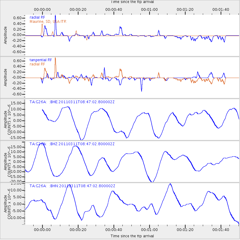
G26A Maurine, SD, USA - Earthquake Result Viewer
*The percent match for this event was below the threshold and hence no stack was calculated.
| Earthquake location: |
Near East Coast Of Honshu, Japan |
| Earthquake latitude/longitude: |
36.0/141.0 |
| Earthquake time(UTC): |
2011/03/11 (070) 08:35:22 GMT |
| Earthquake Depth: |
20 km |
| Earthquake Magnitude: |
5.6 MB |
| Earthquake Catalog/Contributor: |
WHDF/NEIC |
|
| Network: |
TA USArray Transportable Network (new EarthScope stations) |
| Station: |
G26A Maurine, SD, USA |
| Lat/Lon: |
45.29 N/102.60 W |
| Elevation: |
833 m |
|
| Distance: |
80.8 deg |
| Az: |
39.824 deg |
| Baz: |
312.657 deg |
| Ray Param: |
$rayparam |
*The percent match for this event was below the threshold and hence was not used in the summary stack. |
|
| Radial Match: |
73.46037 % |
| Radial Bump: |
340 |
| Transverse Match: |
36.545444 % |
| Transverse Bump: |
295 |
| SOD ConfigId: |
356183 |
| Insert Time: |
2011-08-13 17:58:25.837 +0000 |
| GWidth: |
2.5 |
| Max Bumps: |
400 |
| Tol: |
0.001 |
|
Signal To Noise
| Channel | StoN | STA | LTA |
| TA:G26A: :BHZ:20110311T08:47:02.800002Z | 4.3754363 | 1.6013348E-5 | 3.659829E-6 |
| TA:G26A: :BHN:20110311T08:47:02.800002Z | 0.87593824 | 4.2957754E-6 | 4.904199E-6 |
| TA:G26A: :BHE:20110311T08:47:02.800002Z | 0.99184823 | 8.714058E-6 | 8.785677E-6 |
| Arrivals |
| Ps | |
| PpPs | |
| PsPs/PpSs | |


