You are here: Home > Network List > TA - USArray Transportable Network (new EarthScope stations) Stations List
> Station S33A Kaszmaul Farm, Murdock, KS, USA > Earthquake Result Viewer
S33A Kaszmaul Farm, Murdock, KS, USA - Earthquake Result Viewer
| Earthquake location: |
Near East Coast Of Honshu, Japan |
| Earthquake latitude/longitude: |
36.0/141.0 |
| Earthquake time(UTC): |
2011/03/11 (070) 08:35:22 GMT |
| Earthquake Depth: |
20 km |
| Earthquake Magnitude: |
5.6 MB |
| Earthquake Catalog/Contributor: |
WHDF/NEIC |
|
| Network: |
TA USArray Transportable Network (new EarthScope stations) |
| Station: |
S33A Kaszmaul Farm, Murdock, KS, USA |
| Lat/Lon: |
37.59 N/98.00 W |
| Elevation: |
471 m |
|
| Distance: |
88.6 deg |
| Az: |
42.919 deg |
| Baz: |
315.983 deg |
| Ray Param: |
0.042432502 |
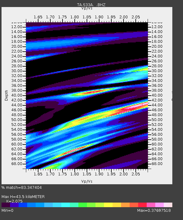
| Estimated Moho Depth: |
43.5 km |
| Estimated Crust Vp/Vs: |
2.08 |
| Assumed Crust Vp: |
6.426 km/s |
| Estimated Crust Vs: |
3.097 km/s |
| Estimated Crust Poisson's Ratio: |
0.35 |
|
| Radial Match: |
83.347404 % |
| Radial Bump: |
355 |
| Transverse Match: |
69.93226 % |
| Transverse Bump: |
137 |
| SOD ConfigId: |
356183 |
| Insert Time: |
2011-08-13 18:03:28.424 +0000 |
| GWidth: |
2.5 |
| Max Bumps: |
400 |
| Tol: |
0.001 |
|

Signal To Noise
| Channel | StoN | STA | LTA |
| TA:S33A: :BHZ:20110311T08:47:42.200027Z | 1.094132 | 8.222563E-6 | 7.515148E-6 |
| TA:S33A: :BHN:20110311T08:47:42.200027Z | 1.401964 | 6.261251E-6 | 4.4660574E-6 |
| TA:S33A: :BHE:20110311T08:47:42.200027Z | 1.437127 | 9.672996E-6 | 6.7307874E-6 |
| Arrivals |
| Ps | 7.4 SECOND |
| PpPs | 20 SECOND |
| PsPs/PpSs | 28 SECOND |


