You are here: Home > Network List > AZ - ANZA Regional Network Stations List
> Station LVA2 AZ.LVA2 > Earthquake Result Viewer
LVA2 AZ.LVA2 - Earthquake Result Viewer

| Earthquake location: |
Kuril Islands |
| Earthquake latitude/longitude: |
44.6/149.4 |
| Earthquake time(UTC): |
1995/12/03 (337) 18:01:08 GMT |
| Earthquake Depth: |
33 km |
| Earthquake Magnitude: |
6.6 MB, 8.0 MS |
| Earthquake Catalog/Contributor: |
WHDF/NEIC |
|
| Network: |
AZ ANZA Regional Network |
| Station: |
LVA2 AZ.LVA2 |
| Lat/Lon: |
33.35 N/116.56 W |
| Elevation: |
1435 m |
|
| Distance: |
70.1 deg |
| Az: |
62.609 deg |
| Baz: |
310.692 deg |
| Ray Param: |
0.055153426 |
| Estimated Moho Depth: |
10.0 km |
| Estimated Crust Vp/Vs: |
1.60 |
| Assumed Crust Vp: |
6.264 km/s |
| Estimated Crust Vs: |
3.915 km/s |
| Estimated Crust Poisson's Ratio: |
0.18 |
|
| Radial Match: |
99.999954 % |
| Radial Bump: |
2 |
| Transverse Match: |
100.0 % |
| Transverse Bump: |
2 |
| SOD ConfigId: |
6273 |
| Insert Time: |
2010-02-26 19:47:49.901 +0000 |
| GWidth: |
2.5 |
| Max Bumps: |
400 |
| Tol: |
0.001 |
|
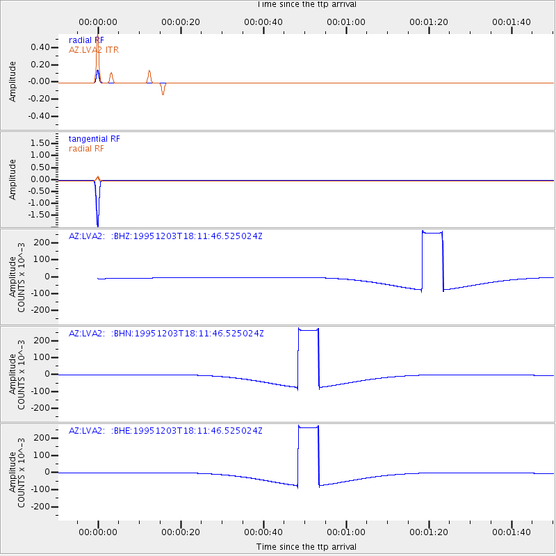
Signal To Noise
| Channel | StoN | STA | LTA |
| AZ:LVA2: :BHN:19951203T18:11:46.525024Z | 1.6645517 | 0.003114525 | 0.0018710893 |
| AZ:LVA2: :BHE:19951203T18:11:46.525024Z | 1.664906 | 0.003115371 | 0.0018711992 |
| AZ:LVA2: :BHZ:19951203T18:11:46.525024Z | 1.6647599 | 0.0031159066 | 0.0018716854 |
| Arrivals |
| Ps | 1.0 SECOND |
| PpPs | 4.0 SECOND |
| PsPs/PpSs | 5.0 SECOND |


