You are here: Home > Network List > TA - USArray Transportable Network (new EarthScope stations) Stations List
> Station 338A Crockett, TX, USA > Earthquake Result Viewer
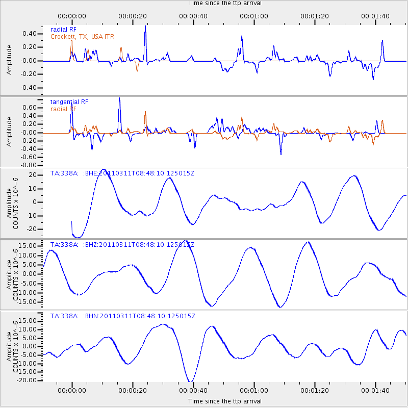
338A Crockett, TX, USA - Earthquake Result Viewer
*The percent match for this event was below the threshold and hence no stack was calculated.
| Earthquake location: |
Near East Coast Of Honshu, Japan |
| Earthquake latitude/longitude: |
36.0/141.0 |
| Earthquake time(UTC): |
2011/03/11 (070) 08:35:22 GMT |
| Earthquake Depth: |
20 km |
| Earthquake Magnitude: |
5.6 MB |
| Earthquake Catalog/Contributor: |
WHDF/NEIC |
|
| Network: |
TA USArray Transportable Network (new EarthScope stations) |
| Station: |
338A Crockett, TX, USA |
| Lat/Lon: |
31.36 N/95.31 W |
| Elevation: |
137 m |
|
| Distance: |
94.7 deg |
| Az: |
45.566 deg |
| Baz: |
317.425 deg |
| Ray Param: |
$rayparam |
*The percent match for this event was below the threshold and hence was not used in the summary stack. |
|
| Radial Match: |
69.825294 % |
| Radial Bump: |
329 |
| Transverse Match: |
74.953674 % |
| Transverse Bump: |
308 |
| SOD ConfigId: |
356183 |
| Insert Time: |
2011-08-13 18:09:04.754 +0000 |
| GWidth: |
2.5 |
| Max Bumps: |
400 |
| Tol: |
0.001 |
|
Signal To Noise
| Channel | StoN | STA | LTA |
| TA:338A: :BHZ:20110311T08:48:10.125015Z | 1.730514 | 1.0660635E-5 | 6.1603864E-6 |
| TA:338A: :BHN:20110311T08:48:10.125015Z | 1.2823111 | 3.8509966E-6 | 3.0031688E-6 |
| TA:338A: :BHE:20110311T08:48:10.125015Z | 1.0417053 | 1.61819E-5 | 1.5534051E-5 |
| Arrivals |
| Ps | |
| PpPs | |
| PsPs/PpSs | |


