You are here: Home > Network List > TA - USArray Transportable Network (new EarthScope stations) Stations List
> Station I35A Creekview Farms, Bingham Lake, MN, USA > Earthquake Result Viewer
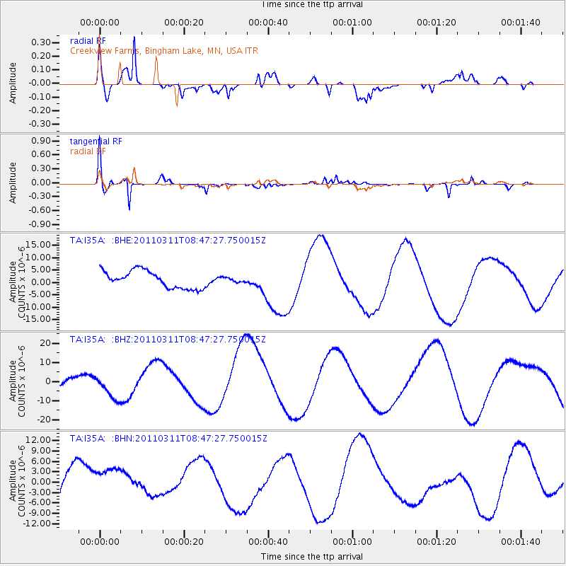
I35A Creekview Farms, Bingham Lake, MN, USA - Earthquake Result Viewer
*The percent match for this event was below the threshold and hence no stack was calculated.
| Earthquake location: |
Near East Coast Of Honshu, Japan |
| Earthquake latitude/longitude: |
36.0/141.0 |
| Earthquake time(UTC): |
2011/03/11 (070) 08:35:22 GMT |
| Earthquake Depth: |
20 km |
| Earthquake Magnitude: |
5.6 MB |
| Earthquake Catalog/Contributor: |
WHDF/NEIC |
|
| Network: |
TA USArray Transportable Network (new EarthScope stations) |
| Station: |
I35A Creekview Farms, Bingham Lake, MN, USA |
| Lat/Lon: |
43.86 N/94.98 W |
| Elevation: |
428 m |
|
| Distance: |
85.6 deg |
| Az: |
36.959 deg |
| Baz: |
317.649 deg |
| Ray Param: |
$rayparam |
*The percent match for this event was below the threshold and hence was not used in the summary stack. |
|
| Radial Match: |
67.09674 % |
| Radial Bump: |
400 |
| Transverse Match: |
81.95686 % |
| Transverse Bump: |
348 |
| SOD ConfigId: |
356183 |
| Insert Time: |
2011-08-13 18:18:55.529 +0000 |
| GWidth: |
2.5 |
| Max Bumps: |
400 |
| Tol: |
0.001 |
|
Signal To Noise
| Channel | StoN | STA | LTA |
| TA:I35A: :BHZ:20110311T08:47:27.750015Z | 1.8233399 | 7.3098804E-6 | 4.009061E-6 |
| TA:I35A: :BHN:20110311T08:47:27.750015Z | 1.0403092 | 5.196445E-6 | 4.9950963E-6 |
| TA:I35A: :BHE:20110311T08:47:27.750015Z | 0.25771192 | 8.9436344E-7 | 3.4704E-6 |
| Arrivals |
| Ps | |
| PpPs | |
| PsPs/PpSs | |


