You are here: Home > Network List > TA - USArray Transportable Network (new EarthScope stations) Stations List
> Station O03D Paynes Creek, CA, USA > Earthquake Result Viewer
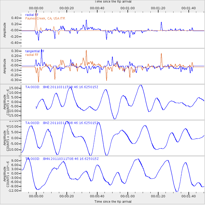
O03D Paynes Creek, CA, USA - Earthquake Result Viewer
*The percent match for this event was below the threshold and hence no stack was calculated.
| Earthquake location: |
Near East Coast Of Honshu, Japan |
| Earthquake latitude/longitude: |
36.0/141.0 |
| Earthquake time(UTC): |
2011/03/11 (070) 08:35:22 GMT |
| Earthquake Depth: |
20 km |
| Earthquake Magnitude: |
5.6 MB |
| Earthquake Catalog/Contributor: |
WHDF/NEIC |
|
| Network: |
TA USArray Transportable Network (new EarthScope stations) |
| Station: |
O03D Paynes Creek, CA, USA |
| Lat/Lon: |
40.29 N/121.80 W |
| Elevation: |
968 m |
|
| Distance: |
72.6 deg |
| Az: |
52.684 deg |
| Baz: |
302.563 deg |
| Ray Param: |
$rayparam |
*The percent match for this event was below the threshold and hence was not used in the summary stack. |
|
| Radial Match: |
74.20664 % |
| Radial Bump: |
295 |
| Transverse Match: |
42.244305 % |
| Transverse Bump: |
331 |
| SOD ConfigId: |
356183 |
| Insert Time: |
2011-08-13 18:19:51.523 +0000 |
| GWidth: |
2.5 |
| Max Bumps: |
400 |
| Tol: |
0.001 |
|
Signal To Noise
| Channel | StoN | STA | LTA |
| TA:O03D: :BHZ:20110311T08:46:16.625015Z | 0.5125802 | 4.3464875E-6 | 8.479625E-6 |
| TA:O03D: :BHN:20110311T08:46:16.625015Z | 1.6076565 | 1.0233505E-5 | 6.36548E-6 |
| TA:O03D: :BHE:20110311T08:46:16.625015Z | 1.4239091 | 9.917352E-6 | 6.9648772E-6 |
| Arrivals |
| Ps | |
| PpPs | |
| PsPs/PpSs | |


