You are here: Home > Network List > TA - USArray Transportable Network (new EarthScope stations) Stations List
> Station A32A Rocking H Ranch, Lancaster, MN, USA > Earthquake Result Viewer
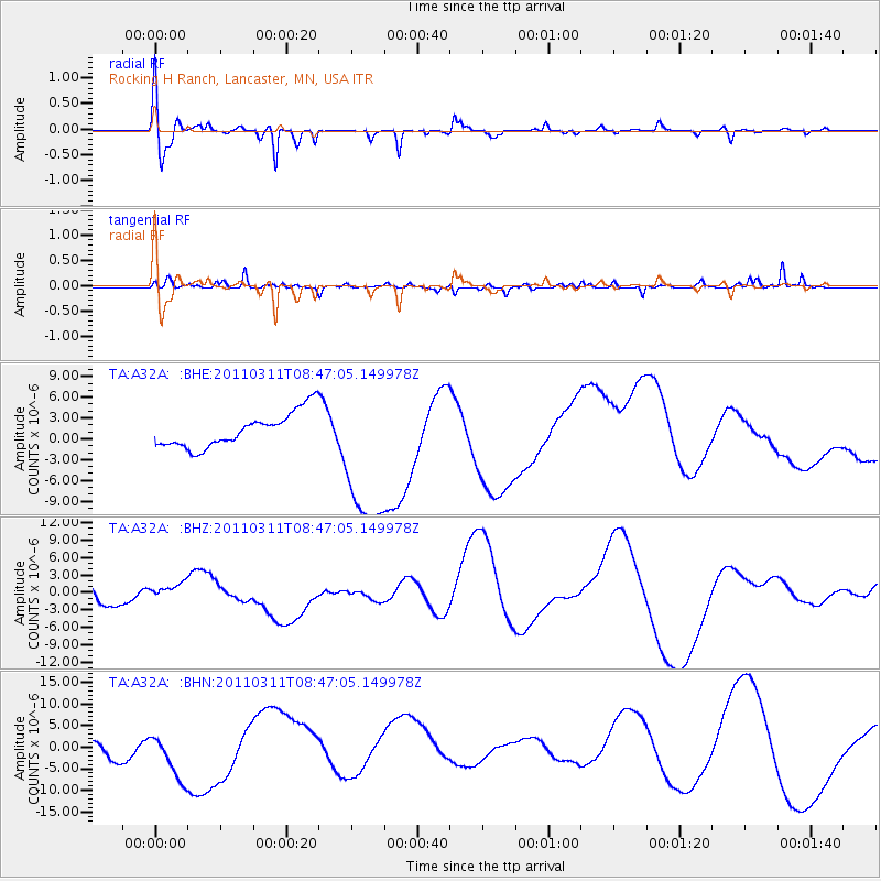
A32A Rocking H Ranch, Lancaster, MN, USA - Earthquake Result Viewer
*The percent match for this event was below the threshold and hence no stack was calculated.
| Earthquake location: |
Near East Coast Of Honshu, Japan |
| Earthquake latitude/longitude: |
36.0/141.0 |
| Earthquake time(UTC): |
2011/03/11 (070) 08:35:22 GMT |
| Earthquake Depth: |
20 km |
| Earthquake Magnitude: |
5.6 MB |
| Earthquake Catalog/Contributor: |
WHDF/NEIC |
|
| Network: |
TA USArray Transportable Network (new EarthScope stations) |
| Station: |
A32A Rocking H Ranch, Lancaster, MN, USA |
| Lat/Lon: |
48.92 N/96.49 W |
| Elevation: |
322 m |
|
| Distance: |
81.2 deg |
| Az: |
34.25 deg |
| Baz: |
316.247 deg |
| Ray Param: |
$rayparam |
*The percent match for this event was below the threshold and hence was not used in the summary stack. |
|
| Radial Match: |
57.753498 % |
| Radial Bump: |
400 |
| Transverse Match: |
26.983578 % |
| Transverse Bump: |
222 |
| SOD ConfigId: |
356183 |
| Insert Time: |
2011-08-13 18:26:48.359 +0000 |
| GWidth: |
2.5 |
| Max Bumps: |
400 |
| Tol: |
0.001 |
|
Signal To Noise
| Channel | StoN | STA | LTA |
| TA:A32A: :BHZ:20110311T08:47:05.149978Z | 0.42348397 | 2.1820642E-6 | 5.152649E-6 |
| TA:A32A: :BHN:20110311T08:47:05.149978Z | 1.3573899 | 6.1207147E-6 | 4.5091792E-6 |
| TA:A32A: :BHE:20110311T08:47:05.149978Z | 4.3612056 | 1.0864257E-5 | 2.4911135E-6 |
| Arrivals |
| Ps | |
| PpPs | |
| PsPs/PpSs | |


