You are here: Home > Network List > US - United States National Seismic Network Stations List
> Station HAWA Hanford, Washington, USA > Earthquake Result Viewer
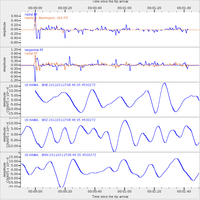
HAWA Hanford, Washington, USA - Earthquake Result Viewer
*The percent match for this event was below the threshold and hence no stack was calculated.
| Earthquake location: |
Near East Coast Of Honshu, Japan |
| Earthquake latitude/longitude: |
36.0/141.0 |
| Earthquake time(UTC): |
2011/03/11 (070) 08:35:22 GMT |
| Earthquake Depth: |
20 km |
| Earthquake Magnitude: |
5.6 MB |
| Earthquake Catalog/Contributor: |
WHDF/NEIC |
|
| Network: |
US United States National Seismic Network |
| Station: |
HAWA Hanford, Washington, USA |
| Lat/Lon: |
46.39 N/119.53 W |
| Elevation: |
364 m |
|
| Distance: |
70.7 deg |
| Az: |
46.325 deg |
| Baz: |
302.113 deg |
| Ray Param: |
$rayparam |
*The percent match for this event was below the threshold and hence was not used in the summary stack. |
|
| Radial Match: |
74.63121 % |
| Radial Bump: |
374 |
| Transverse Match: |
67.684975 % |
| Transverse Bump: |
354 |
| SOD ConfigId: |
356183 |
| Insert Time: |
2011-08-13 18:41:08.559 +0000 |
| GWidth: |
2.5 |
| Max Bumps: |
400 |
| Tol: |
0.001 |
|
Signal To Noise
| Channel | StoN | STA | LTA |
| US:HAWA: :BHZ:20110311T08:46:05.450027Z | 2.6994479 | 9.277611E-6 | 3.436855E-6 |
| US:HAWA: :BHN:20110311T08:46:05.450027Z | 0.33861348 | 1.3791989E-6 | 4.0730774E-6 |
| US:HAWA: :BHE:20110311T08:46:05.450027Z | 3.8700216 | 1.40872635E-5 | 3.6400995E-6 |
| Arrivals |
| Ps | |
| PpPs | |
| PsPs/PpSs | |


