You are here: Home > Network List > CI - Caltech Regional Seismic Network Stations List
> Station MPM Manuel Prospect Mine, California, USA > Earthquake Result Viewer
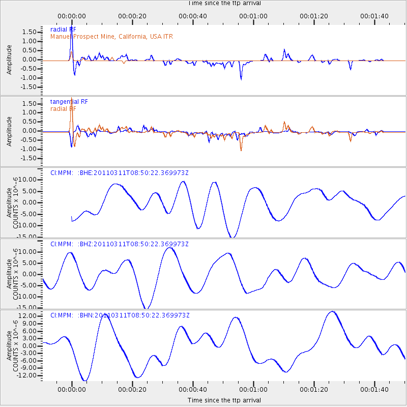
MPM Manuel Prospect Mine, California, USA - Earthquake Result Viewer
*The percent match for this event was below the threshold and hence no stack was calculated.
| Earthquake location: |
Off East Coast Of Honshu, Japan |
| Earthquake latitude/longitude: |
37.6/142.8 |
| Earthquake time(UTC): |
2011/03/11 (070) 08:39:12 GMT |
| Earthquake Depth: |
46 km |
| Earthquake Magnitude: |
5.5 MB |
| Earthquake Catalog/Contributor: |
WHDF/NEIC |
|
| Network: |
CI Caltech Regional Seismic Network |
| Station: |
MPM Manuel Prospect Mine, California, USA |
| Lat/Lon: |
36.06 N/117.49 W |
| Elevation: |
185 m |
|
| Distance: |
75.7 deg |
| Az: |
55.515 deg |
| Baz: |
306.144 deg |
| Ray Param: |
$rayparam |
*The percent match for this event was below the threshold and hence was not used in the summary stack. |
|
| Radial Match: |
52.767086 % |
| Radial Bump: |
400 |
| Transverse Match: |
55.0219 % |
| Transverse Bump: |
400 |
| SOD ConfigId: |
356183 |
| Insert Time: |
2011-08-13 19:09:08.010 +0000 |
| GWidth: |
2.5 |
| Max Bumps: |
400 |
| Tol: |
0.001 |
|
Signal To Noise
| Channel | StoN | STA | LTA |
| CI:MPM: :BHZ:20110311T08:50:22.369973Z | 2.0108976 | 7.23272E-6 | 3.5967619E-6 |
| CI:MPM: :BHN:20110311T08:50:22.369973Z | 1.7644917 | 1.2845547E-5 | 7.2800267E-6 |
| CI:MPM: :BHE:20110311T08:50:22.369973Z | 0.5584248 | 2.8733946E-6 | 5.145536E-6 |
| Arrivals |
| Ps | |
| PpPs | |
| PsPs/PpSs | |


