You are here: Home > Network List > TA - USArray Transportable Network (new EarthScope stations) Stations List
> Station 121A Cookes Peak, Deming, NM, USA > Earthquake Result Viewer
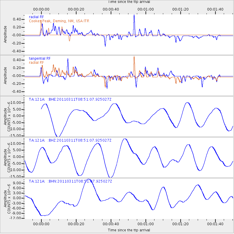
121A Cookes Peak, Deming, NM, USA - Earthquake Result Viewer
*The percent match for this event was below the threshold and hence no stack was calculated.
| Earthquake location: |
Off East Coast Of Honshu, Japan |
| Earthquake latitude/longitude: |
37.6/142.8 |
| Earthquake time(UTC): |
2011/03/11 (070) 08:39:12 GMT |
| Earthquake Depth: |
46 km |
| Earthquake Magnitude: |
5.5 MB |
| Earthquake Catalog/Contributor: |
WHDF/NEIC |
|
| Network: |
TA USArray Transportable Network (new EarthScope stations) |
| Station: |
121A Cookes Peak, Deming, NM, USA |
| Lat/Lon: |
32.53 N/107.79 W |
| Elevation: |
1652 m |
|
| Distance: |
84.1 deg |
| Az: |
53.201 deg |
| Baz: |
311.192 deg |
| Ray Param: |
$rayparam |
*The percent match for this event was below the threshold and hence was not used in the summary stack. |
|
| Radial Match: |
64.53258 % |
| Radial Bump: |
400 |
| Transverse Match: |
43.901676 % |
| Transverse Bump: |
322 |
| SOD ConfigId: |
356183 |
| Insert Time: |
2011-08-13 19:40:24.069 +0000 |
| GWidth: |
2.5 |
| Max Bumps: |
400 |
| Tol: |
0.001 |
|
Signal To Noise
| Channel | StoN | STA | LTA |
| TA:121A: :BHZ:20110311T08:51:07.925027Z | 0.59120333 | 5.609505E-6 | 9.4882835E-6 |
| TA:121A: :BHN:20110311T08:51:07.925027Z | 2.517675 | 1.7228225E-5 | 6.8429113E-6 |
| TA:121A: :BHE:20110311T08:51:07.925027Z | 0.1863678 | 1.4936005E-6 | 8.014263E-6 |
| Arrivals |
| Ps | |
| PpPs | |
| PsPs/PpSs | |


