You are here: Home > Network List > TA - USArray Transportable Network (new EarthScope stations) Stations List
> Station 339A Huntington, TX, USA > Earthquake Result Viewer
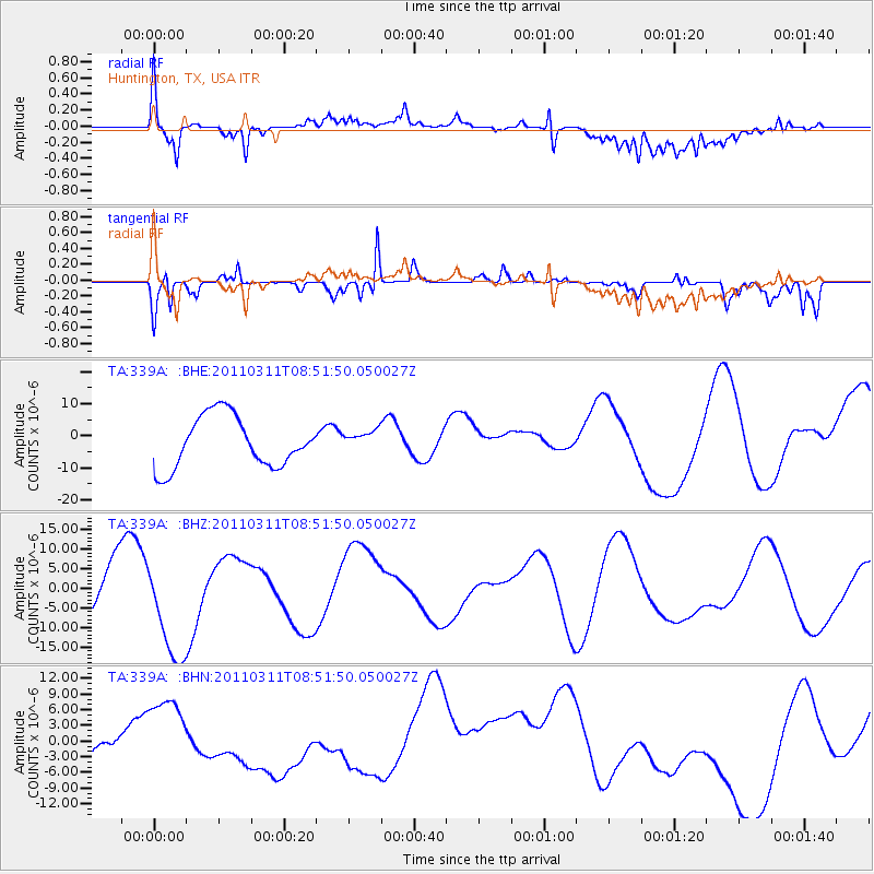
339A Huntington, TX, USA - Earthquake Result Viewer
*The percent match for this event was below the threshold and hence no stack was calculated.
| Earthquake location: |
Off East Coast Of Honshu, Japan |
| Earthquake latitude/longitude: |
37.6/142.8 |
| Earthquake time(UTC): |
2011/03/11 (070) 08:39:12 GMT |
| Earthquake Depth: |
46 km |
| Earthquake Magnitude: |
5.5 MB |
| Earthquake Catalog/Contributor: |
WHDF/NEIC |
|
| Network: |
TA USArray Transportable Network (new EarthScope stations) |
| Station: |
339A Huntington, TX, USA |
| Lat/Lon: |
31.33 N/94.56 W |
| Elevation: |
82 m |
|
| Distance: |
93.0 deg |
| Az: |
46.16 deg |
| Baz: |
318.0 deg |
| Ray Param: |
$rayparam |
*The percent match for this event was below the threshold and hence was not used in the summary stack. |
|
| Radial Match: |
67.76844 % |
| Radial Bump: |
400 |
| Transverse Match: |
74.21025 % |
| Transverse Bump: |
400 |
| SOD ConfigId: |
356183 |
| Insert Time: |
2011-08-13 19:57:20.988 +0000 |
| GWidth: |
2.5 |
| Max Bumps: |
400 |
| Tol: |
0.001 |
|
Signal To Noise
| Channel | StoN | STA | LTA |
| TA:339A: :BHZ:20110311T08:51:50.050027Z | 1.7378953 | 1.3659071E-5 | 7.859548E-6 |
| TA:339A: :BHN:20110311T08:51:50.050027Z | 1.0983021 | 8.045559E-6 | 7.325452E-6 |
| TA:339A: :BHE:20110311T08:51:50.050027Z | 0.40503192 | 3.2090325E-6 | 7.922912E-6 |
| Arrivals |
| Ps | |
| PpPs | |
| PsPs/PpSs | |


