You are here: Home > Network List > TA - USArray Transportable Network (new EarthScope stations) Stations List
> Station S34A Willow Spring Farm, Andover, KS, USA > Earthquake Result Viewer
S34A Willow Spring Farm, Andover, KS, USA - Earthquake Result Viewer

| Earthquake location: |
Off East Coast Of Honshu, Japan |
| Earthquake latitude/longitude: |
37.6/142.8 |
| Earthquake time(UTC): |
2011/03/11 (070) 08:39:12 GMT |
| Earthquake Depth: |
46 km |
| Earthquake Magnitude: |
5.5 MB |
| Earthquake Catalog/Contributor: |
WHDF/NEIC |
|
| Network: |
TA USArray Transportable Network (new EarthScope stations) |
| Station: |
S34A Willow Spring Farm, Andover, KS, USA |
| Lat/Lon: |
37.70 N/97.11 W |
| Elevation: |
373 m |
|
| Distance: |
86.9 deg |
| Az: |
43.403 deg |
| Baz: |
316.553 deg |
| Ray Param: |
0.043651957 |
| Estimated Moho Depth: |
49.75 km |
| Estimated Crust Vp/Vs: |
2.08 |
| Assumed Crust Vp: |
6.483 km/s |
| Estimated Crust Vs: |
3.117 km/s |
| Estimated Crust Poisson's Ratio: |
0.35 |
|
| Radial Match: |
82.727936 % |
| Radial Bump: |
334 |
| Transverse Match: |
62.50635 % |
| Transverse Bump: |
300 |
| SOD ConfigId: |
356183 |
| Insert Time: |
2011-08-13 19:58:17.595 +0000 |
| GWidth: |
2.5 |
| Max Bumps: |
400 |
| Tol: |
0.001 |
|
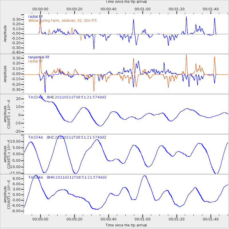
Signal To Noise
| Channel | StoN | STA | LTA |
| TA:S34A: :BHZ:20110311T08:51:21.57499Z | 2.0481508 | 1.2864691E-5 | 6.281125E-6 |
| TA:S34A: :BHN:20110311T08:51:21.57499Z | 1.2429621 | 5.189321E-6 | 4.174963E-6 |
| TA:S34A: :BHE:20110311T08:51:21.57499Z | 1.3310138 | 1.3398523E-5 | 1.0066404E-5 |
| Arrivals |
| Ps | 8.5 SECOND |
| PpPs | 23 SECOND |
| PsPs/PpSs | 32 SECOND |


