You are here: Home > Network List > TA - USArray Transportable Network (new EarthScope stations) Stations List
> Station L32A Elgin, NE, USA > Earthquake Result Viewer
L32A Elgin, NE, USA - Earthquake Result Viewer
*The percent match for this event was below the threshold and hence no stack was calculated.
| Earthquake location: |
Off East Coast Of Honshu, Japan |
| Earthquake latitude/longitude: |
37.6/142.8 |
| Earthquake time(UTC): |
2011/03/11 (070) 08:39:12 GMT |
| Earthquake Depth: |
46 km |
| Earthquake Magnitude: |
5.5 MB |
| Earthquake Catalog/Contributor: |
WHDF/NEIC |
|
| Network: |
TA USArray Transportable Network (new EarthScope stations) |
| Station: |
L32A Elgin, NE, USA |
| Lat/Lon: |
42.00 N/98.01 W |
| Elevation: |
586 m |
|
| Distance: |
83.3 deg |
| Az: |
40.915 deg |
| Baz: |
315.767 deg |
| Ray Param: |
$rayparam |
*The percent match for this event was below the threshold and hence was not used in the summary stack. |
|
| Radial Match: |
72.637695 % |
| Radial Bump: |
400 |
| Transverse Match: |
63.427246 % |
| Transverse Bump: |
400 |
| SOD ConfigId: |
356183 |
| Insert Time: |
2011-08-13 20:04:36.185 +0000 |
| GWidth: |
2.5 |
| Max Bumps: |
400 |
| Tol: |
0.001 |
|
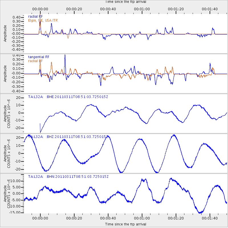
Signal To Noise
| Channel | StoN | STA | LTA |
| TA:L32A: :BHZ:20110311T08:51:03.725015Z | 1.4544723 | 1.8229683E-5 | 1.2533537E-5 |
| TA:L32A: :BHN:20110311T08:51:03.725015Z | 1.1386365 | 7.755803E-6 | 6.8114837E-6 |
| TA:L32A: :BHE:20110311T08:51:03.725015Z | 2.4081857 | 1.4761545E-5 | 6.1297364E-6 |
| Arrivals |
| Ps | |
| PpPs | |
| PsPs/PpSs | |


