You are here: Home > Network List > TA - USArray Transportable Network (new EarthScope stations) Stations List
> Station G34A Benson, MN, USA > Earthquake Result Viewer
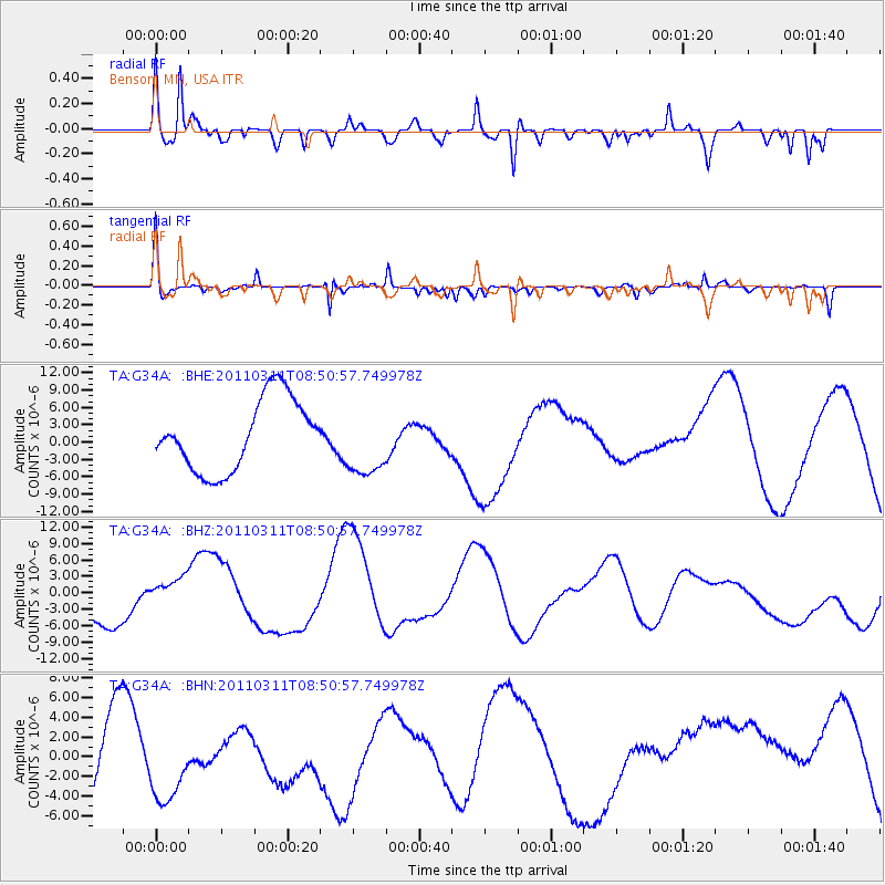
G34A Benson, MN, USA - Earthquake Result Viewer
*The percent match for this event was below the threshold and hence no stack was calculated.
| Earthquake location: |
Off East Coast Of Honshu, Japan |
| Earthquake latitude/longitude: |
37.6/142.8 |
| Earthquake time(UTC): |
2011/03/11 (070) 08:39:12 GMT |
| Earthquake Depth: |
46 km |
| Earthquake Magnitude: |
5.5 MB |
| Earthquake Catalog/Contributor: |
WHDF/NEIC |
|
| Network: |
TA USArray Transportable Network (new EarthScope stations) |
| Station: |
G34A Benson, MN, USA |
| Lat/Lon: |
45.24 N/95.64 W |
| Elevation: |
316 m |
|
| Distance: |
82.1 deg |
| Az: |
37.408 deg |
| Baz: |
316.953 deg |
| Ray Param: |
$rayparam |
*The percent match for this event was below the threshold and hence was not used in the summary stack. |
|
| Radial Match: |
67.15431 % |
| Radial Bump: |
313 |
| Transverse Match: |
59.649574 % |
| Transverse Bump: |
235 |
| SOD ConfigId: |
356183 |
| Insert Time: |
2011-08-13 20:11:32.091 +0000 |
| GWidth: |
2.5 |
| Max Bumps: |
400 |
| Tol: |
0.001 |
|
Signal To Noise
| Channel | StoN | STA | LTA |
| TA:G34A: :BHZ:20110311T08:50:57.749978Z | 0.5028271 | 4.588203E-6 | 9.124813E-6 |
| TA:G34A: :BHN:20110311T08:50:57.749978Z | 0.73238426 | 5.8330616E-6 | 7.964482E-6 |
| TA:G34A: :BHE:20110311T08:50:57.749978Z | 0.9686121 | 5.9318745E-6 | 6.1240976E-6 |
| Arrivals |
| Ps | |
| PpPs | |
| PsPs/PpSs | |


