You are here: Home > Network List > TA - USArray Transportable Network (new EarthScope stations) Stations List
> Station H36A Jessenland, Henderson, MN, USA > Earthquake Result Viewer
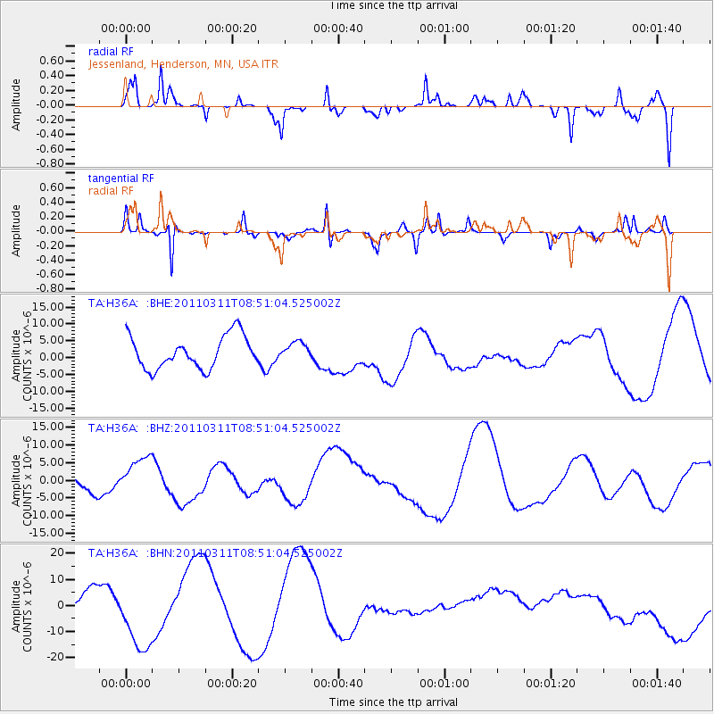
H36A Jessenland, Henderson, MN, USA - Earthquake Result Viewer
*The percent match for this event was below the threshold and hence no stack was calculated.
| Earthquake location: |
Off East Coast Of Honshu, Japan |
| Earthquake latitude/longitude: |
37.6/142.8 |
| Earthquake time(UTC): |
2011/03/11 (070) 08:39:12 GMT |
| Earthquake Depth: |
46 km |
| Earthquake Magnitude: |
5.5 MB |
| Earthquake Catalog/Contributor: |
WHDF/NEIC |
|
| Network: |
TA USArray Transportable Network (new EarthScope stations) |
| Station: |
H36A Jessenland, Henderson, MN, USA |
| Lat/Lon: |
44.58 N/93.93 W |
| Elevation: |
311 m |
|
| Distance: |
83.5 deg |
| Az: |
36.957 deg |
| Baz: |
318.1 deg |
| Ray Param: |
$rayparam |
*The percent match for this event was below the threshold and hence was not used in the summary stack. |
|
| Radial Match: |
54.741436 % |
| Radial Bump: |
254 |
| Transverse Match: |
72.06906 % |
| Transverse Bump: |
276 |
| SOD ConfigId: |
356183 |
| Insert Time: |
2011-08-13 20:13:44.545 +0000 |
| GWidth: |
2.5 |
| Max Bumps: |
400 |
| Tol: |
0.001 |
|
Signal To Noise
| Channel | StoN | STA | LTA |
| TA:H36A: :BHZ:20110311T08:51:04.525002Z | 1.2179841 | 6.2658114E-6 | 5.1444117E-6 |
| TA:H36A: :BHN:20110311T08:51:04.525002Z | 2.1663327 | 1.349051E-5 | 6.2273493E-6 |
| TA:H36A: :BHE:20110311T08:51:04.525002Z | 0.5205763 | 2.5043973E-6 | 4.810817E-6 |
| Arrivals |
| Ps | |
| PpPs | |
| PsPs/PpSs | |


