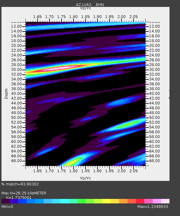
LVA2 AZ.LVA2 - Earthquake Result Viewer
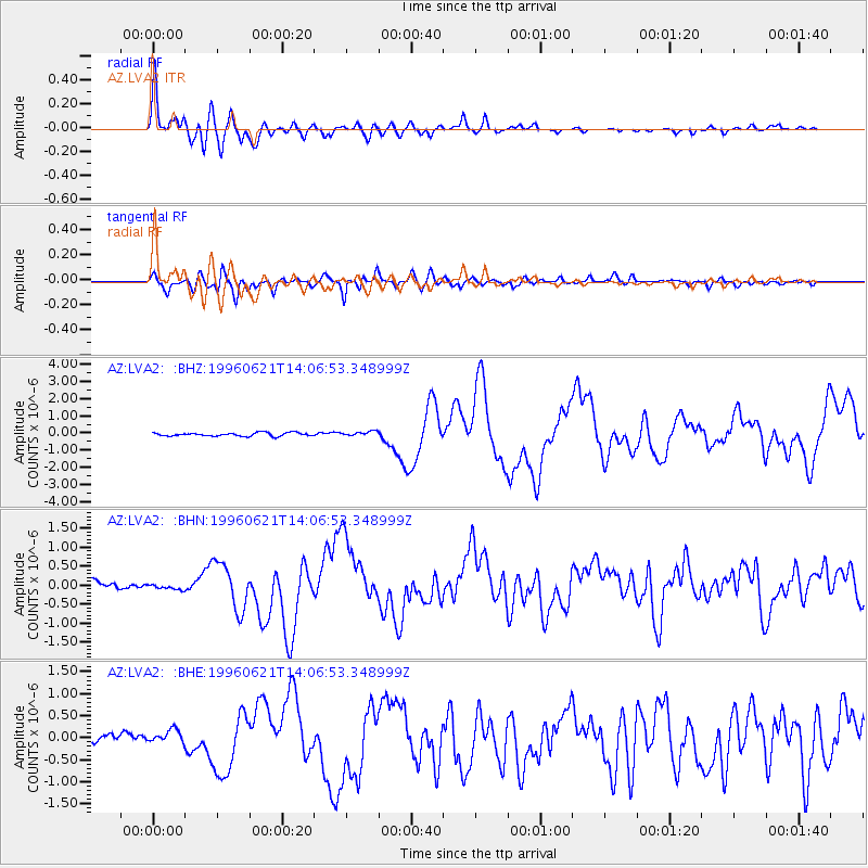
Earthquake location: Off East Coast Of Kamchatka
Earthquake latitude/longitude: 51.6/159.1
Earthquake time(UTC): 1996/06/21 (173) 13:57:10 GMT
Earthquake Depth: 20 km
Earthquake Magnitude: 6.0 MB, 6.6 MS, 7.0 UNKNOWN, 6.5 MS
Earthquake Catalog/Contributor: WHDF/NEIC
Network: AZ ANZA Regional Network
Station: LVA2 AZ.LVA2
Lat/Lon: 33.35 N/116.56 W
Elevation: 1435 m
Distance: 61.4 deg
Az: 71.616 deg
Baz: 314.957 deg
Ray Param: 0.060898222
Estimated Moho Depth: 29.25 km
Estimated Crust Vp/Vs: 1.74
Assumed Crust Vp: 6.264 km/s
Estimated Crust Vs: 3.605 km/s
Estimated Crust Poisson's Ratio: 0.25
Radial Match: 93.90302 %
Radial Bump: 400
Transverse Match: 84.09027 %
Transverse Bump: 400
SOD ConfigId: 6273
Insert Time: 2010-02-26 19:48:23.372 +0000
GWidth: 2.5
Max Bumps: 400
Tol: 0.001

Signal To Noise

ChannelStoNSTALTA
AZ:LVA2: :BHN:19960621T14:06:53.348999Z0.885919758.2684E-89.3331245E-8
AZ:LVA2: :BHE:19960621T14:06:53.348999Z1.0723011.4861457E-71.3859409E-7
AZ:LVA2: :BHZ:19960621T14:06:53.348999Z1.38833691.3566364E-79.771665E-8
Arrivals
Ps3.6 SECOND
PpPs12 SECOND
PsPs/PpSs16 SECOND