You are here: Home > Network List > TA - USArray Transportable Network (new EarthScope stations) Stations List
> Station R38A Fenwick Farm, Montrose, MO, USA > Earthquake Result Viewer
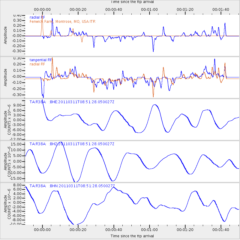
R38A Fenwick Farm, Montrose, MO, USA - Earthquake Result Viewer
*The percent match for this event was below the threshold and hence no stack was calculated.
| Earthquake location: |
Off East Coast Of Honshu, Japan |
| Earthquake latitude/longitude: |
37.6/142.8 |
| Earthquake time(UTC): |
2011/03/11 (070) 08:39:12 GMT |
| Earthquake Depth: |
46 km |
| Earthquake Magnitude: |
5.5 MB |
| Earthquake Catalog/Contributor: |
WHDF/NEIC |
|
| Network: |
TA USArray Transportable Network (new EarthScope stations) |
| Station: |
R38A Fenwick Farm, Montrose, MO, USA |
| Lat/Lon: |
38.19 N/93.91 W |
| Elevation: |
237 m |
|
| Distance: |
88.2 deg |
| Az: |
41.205 deg |
| Baz: |
318.422 deg |
| Ray Param: |
$rayparam |
*The percent match for this event was below the threshold and hence was not used in the summary stack. |
|
| Radial Match: |
63.200104 % |
| Radial Bump: |
400 |
| Transverse Match: |
52.07613 % |
| Transverse Bump: |
400 |
| SOD ConfigId: |
356183 |
| Insert Time: |
2011-08-13 20:18:41.648 +0000 |
| GWidth: |
2.5 |
| Max Bumps: |
400 |
| Tol: |
0.001 |
|
Signal To Noise
| Channel | StoN | STA | LTA |
| TA:R38A: :BHZ:20110311T08:51:28.050027Z | 0.9110258 | 7.394023E-6 | 8.116151E-6 |
| TA:R38A: :BHN:20110311T08:51:28.050027Z | 1.2803962 | 6.5660515E-6 | 5.1281404E-6 |
| TA:R38A: :BHE:20110311T08:51:28.050027Z | 2.858169 | 6.7267083E-6 | 2.3535024E-6 |
| Arrivals |
| Ps | |
| PpPs | |
| PsPs/PpSs | |


