You are here: Home > Network List > TA - USArray Transportable Network (new EarthScope stations) Stations List
> Station T38A Diamond, MO, USA > Earthquake Result Viewer
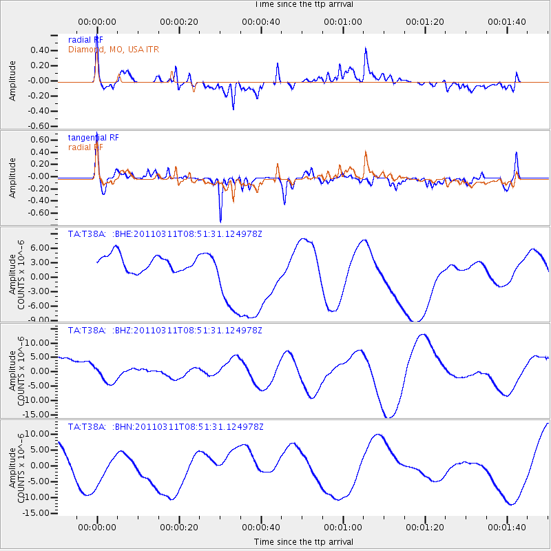
T38A Diamond, MO, USA - Earthquake Result Viewer
*The percent match for this event was below the threshold and hence no stack was calculated.
| Earthquake location: |
Off East Coast Of Honshu, Japan |
| Earthquake latitude/longitude: |
37.6/142.8 |
| Earthquake time(UTC): |
2011/03/11 (070) 08:39:12 GMT |
| Earthquake Depth: |
46 km |
| Earthquake Magnitude: |
5.5 MB |
| Earthquake Catalog/Contributor: |
WHDF/NEIC |
|
| Network: |
TA USArray Transportable Network (new EarthScope stations) |
| Station: |
T38A Diamond, MO, USA |
| Lat/Lon: |
37.04 N/94.29 W |
| Elevation: |
349 m |
|
| Distance: |
88.9 deg |
| Az: |
42.2 deg |
| Baz: |
318.212 deg |
| Ray Param: |
$rayparam |
*The percent match for this event was below the threshold and hence was not used in the summary stack. |
|
| Radial Match: |
38.150745 % |
| Radial Bump: |
400 |
| Transverse Match: |
62.03097 % |
| Transverse Bump: |
400 |
| SOD ConfigId: |
356183 |
| Insert Time: |
2011-08-13 20:20:12.654 +0000 |
| GWidth: |
2.5 |
| Max Bumps: |
400 |
| Tol: |
0.001 |
|
Signal To Noise
| Channel | StoN | STA | LTA |
| TA:T38A: :BHZ:20110311T08:51:31.124978Z | 0.41396227 | 2.4447695E-6 | 5.9057784E-6 |
| TA:T38A: :BHN:20110311T08:51:31.124978Z | 1.6614304 | 6.7933383E-6 | 4.088849E-6 |
| TA:T38A: :BHE:20110311T08:51:31.124978Z | 4.9443164 | 8.133241E-6 | 1.6449678E-6 |
| Arrivals |
| Ps | |
| PpPs | |
| PsPs/PpSs | |


