You are here: Home > Network List > TA - USArray Transportable Network (new EarthScope stations) Stations List
> Station 242A Grayson, LA, USA > Earthquake Result Viewer
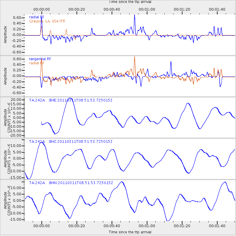
242A Grayson, LA, USA - Earthquake Result Viewer
*The percent match for this event was below the threshold and hence no stack was calculated.
| Earthquake location: |
Off East Coast Of Honshu, Japan |
| Earthquake latitude/longitude: |
37.6/142.8 |
| Earthquake time(UTC): |
2011/03/11 (070) 08:39:12 GMT |
| Earthquake Depth: |
46 km |
| Earthquake Magnitude: |
5.5 MB |
| Earthquake Catalog/Contributor: |
WHDF/NEIC |
|
| Network: |
TA USArray Transportable Network (new EarthScope stations) |
| Station: |
242A Grayson, LA, USA |
| Lat/Lon: |
32.06 N/92.15 W |
| Elevation: |
57 m |
|
| Distance: |
93.8 deg |
| Az: |
44.138 deg |
| Baz: |
319.376 deg |
| Ray Param: |
$rayparam |
*The percent match for this event was below the threshold and hence was not used in the summary stack. |
|
| Radial Match: |
69.37017 % |
| Radial Bump: |
346 |
| Transverse Match: |
51.363083 % |
| Transverse Bump: |
400 |
| SOD ConfigId: |
356183 |
| Insert Time: |
2011-08-13 20:21:47.670 +0000 |
| GWidth: |
2.5 |
| Max Bumps: |
400 |
| Tol: |
0.001 |
|
Signal To Noise
| Channel | StoN | STA | LTA |
| TA:242A: :BHZ:20110311T08:51:53.725015Z | 1.6354235 | 1.0912528E-5 | 6.6726E-6 |
| TA:242A: :BHN:20110311T08:51:53.725015Z | 3.0763931 | 5.8450587E-6 | 1.8999713E-6 |
| TA:242A: :BHE:20110311T08:51:53.725015Z | 0.31710798 | 3.8878775E-6 | 1.22604215E-5 |
| Arrivals |
| Ps | |
| PpPs | |
| PsPs/PpSs | |


