You are here: Home > Network List > UW - Pacific Northwest Regional Seismic Network Stations List
> Station MRBL Marblemount, WA, USA > Earthquake Result Viewer
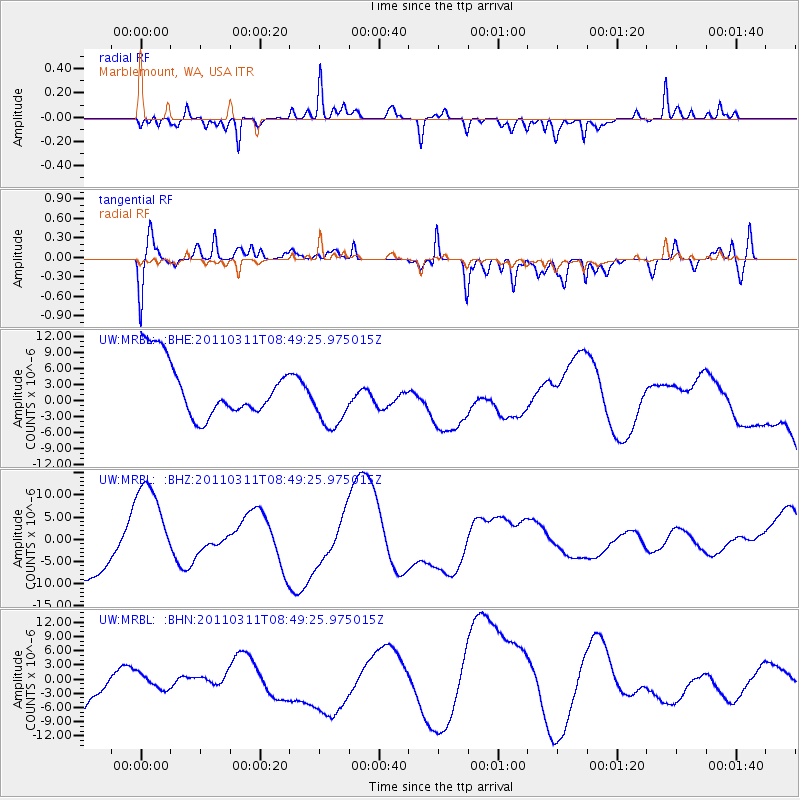
MRBL Marblemount, WA, USA - Earthquake Result Viewer
*The percent match for this event was below the threshold and hence no stack was calculated.
| Earthquake location: |
Off East Coast Of Honshu, Japan |
| Earthquake latitude/longitude: |
37.6/142.8 |
| Earthquake time(UTC): |
2011/03/11 (070) 08:39:12 GMT |
| Earthquake Depth: |
46 km |
| Earthquake Magnitude: |
5.5 MB |
| Earthquake Catalog/Contributor: |
WHDF/NEIC |
|
| Network: |
UW Pacific Northwest Regional Seismic Network |
| Station: |
MRBL Marblemount, WA, USA |
| Lat/Lon: |
48.52 N/121.48 W |
| Elevation: |
75 m |
|
| Distance: |
66.3 deg |
| Az: |
46.243 deg |
| Baz: |
300.415 deg |
| Ray Param: |
$rayparam |
*The percent match for this event was below the threshold and hence was not used in the summary stack. |
|
| Radial Match: |
75.63444 % |
| Radial Bump: |
307 |
| Transverse Match: |
46.947006 % |
| Transverse Bump: |
400 |
| SOD ConfigId: |
356183 |
| Insert Time: |
2011-08-13 20:32:20.954 +0000 |
| GWidth: |
2.5 |
| Max Bumps: |
400 |
| Tol: |
0.001 |
|
Signal To Noise
| Channel | StoN | STA | LTA |
| UW:MRBL: :BHZ:20110311T08:49:25.975015Z | 1.8107599 | 1.0405537E-5 | 5.746503E-6 |
| UW:MRBL: :BHN:20110311T08:49:25.975015Z | 0.4223439 | 4.9381733E-6 | 1.1692304E-5 |
| UW:MRBL: :BHE:20110311T08:49:25.975015Z | 1.1056356 | 5.7880566E-6 | 5.235049E-6 |
| Arrivals |
| Ps | |
| PpPs | |
| PsPs/PpSs | |


