You are here: Home > Network List > CI - Caltech Regional Seismic Network Stations List
> Station LRL Laurel Mtn Radio Fac, Ridgecrest, CA, USA > Earthquake Result Viewer
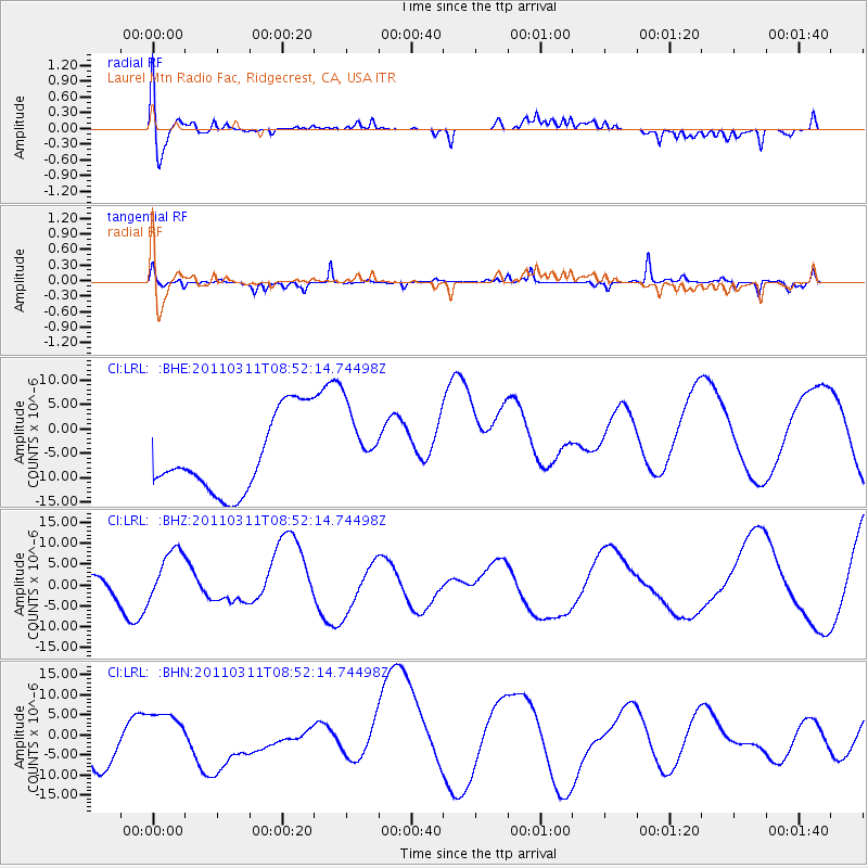
LRL Laurel Mtn Radio Fac, Ridgecrest, CA, USA - Earthquake Result Viewer
*The percent match for this event was below the threshold and hence no stack was calculated.
| Earthquake location: |
Eastern Honshu, Japan |
| Earthquake latitude/longitude: |
37.4/141.0 |
| Earthquake time(UTC): |
2011/03/11 (070) 08:40:56 GMT |
| Earthquake Depth: |
40 km |
| Earthquake Magnitude: |
5.9 MB |
| Earthquake Catalog/Contributor: |
WHDF/NEIC |
|
| Network: |
CI Caltech Regional Seismic Network |
| Station: |
LRL Laurel Mtn Radio Fac, Ridgecrest, CA, USA |
| Lat/Lon: |
35.48 N/117.68 W |
| Elevation: |
1340 m |
|
| Distance: |
77.2 deg |
| Az: |
55.161 deg |
| Baz: |
306.835 deg |
| Ray Param: |
$rayparam |
*The percent match for this event was below the threshold and hence was not used in the summary stack. |
|
| Radial Match: |
71.005554 % |
| Radial Bump: |
400 |
| Transverse Match: |
51.766792 % |
| Transverse Bump: |
242 |
| SOD ConfigId: |
356183 |
| Insert Time: |
2011-08-13 20:56:51.760 +0000 |
| GWidth: |
2.5 |
| Max Bumps: |
400 |
| Tol: |
0.001 |
|
Signal To Noise
| Channel | StoN | STA | LTA |
| CI:LRL: :BHZ:20110311T08:52:14.74498Z | 1.8057647 | 7.3953224E-6 | 4.0953964E-6 |
| CI:LRL: :BHN:20110311T08:52:14.74498Z | 0.16358069 | 1.4872621E-6 | 9.0919175E-6 |
| CI:LRL: :BHE:20110311T08:52:14.74498Z | 1.0034441 | 7.9047595E-6 | 7.877629E-6 |
| Arrivals |
| Ps | |
| PpPs | |
| PsPs/PpSs | |


