You are here: Home > Network List > KN - Kyrgyz Seismic Telemetry Network Stations List
> Station TKM2 KN.TKM2 > Earthquake Result Viewer
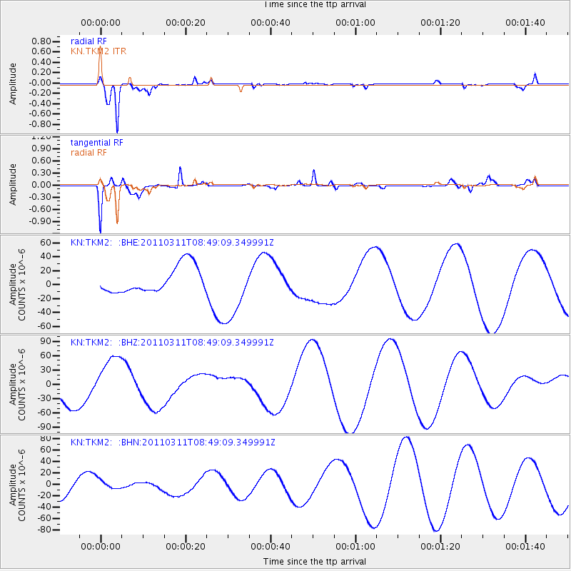
TKM2 KN.TKM2 - Earthquake Result Viewer
*The percent match for this event was below the threshold and hence no stack was calculated.
| Earthquake location: |
Eastern Honshu, Japan |
| Earthquake latitude/longitude: |
37.4/141.0 |
| Earthquake time(UTC): |
2011/03/11 (070) 08:40:56 GMT |
| Earthquake Depth: |
40 km |
| Earthquake Magnitude: |
5.9 MB |
| Earthquake Catalog/Contributor: |
WHDF/NEIC |
|
| Network: |
KN Kyrgyz Seismic Telemetry Network |
| Station: |
TKM2 KN.TKM2 |
| Lat/Lon: |
42.92 N/75.60 E |
| Elevation: |
2020 m |
|
| Distance: |
49.1 deg |
| Az: |
297.98 deg |
| Baz: |
73.1 deg |
| Ray Param: |
$rayparam |
*The percent match for this event was below the threshold and hence was not used in the summary stack. |
|
| Radial Match: |
92.217834 % |
| Radial Bump: |
341 |
| Transverse Match: |
60.240467 % |
| Transverse Bump: |
400 |
| SOD ConfigId: |
356183 |
| Insert Time: |
2011-08-13 21:21:30.920 +0000 |
| GWidth: |
2.5 |
| Max Bumps: |
400 |
| Tol: |
0.001 |
|
Signal To Noise
| Channel | StoN | STA | LTA |
| KN:TKM2: :BHZ:20110311T08:49:09.349991Z | 1.7656949 | 5.1037994E-5 | 2.8905331E-5 |
| KN:TKM2: :BHN:20110311T08:49:09.349991Z | 0.5495446 | 9.773814E-6 | 1.7785298E-5 |
| KN:TKM2: :BHE:20110311T08:49:09.349991Z | 2.28947 | 4.2670843E-5 | 1.8637871E-5 |
| Arrivals |
| Ps | |
| PpPs | |
| PsPs/PpSs | |


