You are here: Home > Network List > TA - USArray Transportable Network (new EarthScope stations) Stations List
> Station T31A Randall Ranch, Ashland, KS, USA > Earthquake Result Viewer
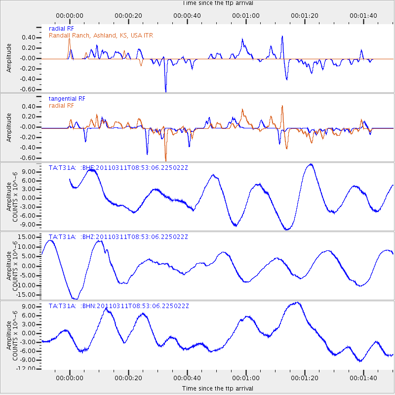
T31A Randall Ranch, Ashland, KS, USA - Earthquake Result Viewer
*The percent match for this event was below the threshold and hence no stack was calculated.
| Earthquake location: |
Eastern Honshu, Japan |
| Earthquake latitude/longitude: |
37.4/141.0 |
| Earthquake time(UTC): |
2011/03/11 (070) 08:40:56 GMT |
| Earthquake Depth: |
40 km |
| Earthquake Magnitude: |
5.9 MB |
| Earthquake Catalog/Contributor: |
WHDF/NEIC |
|
| Network: |
TA USArray Transportable Network (new EarthScope stations) |
| Station: |
T31A Randall Ranch, Ashland, KS, USA |
| Lat/Lon: |
37.10 N/99.68 W |
| Elevation: |
564 m |
|
| Distance: |
87.0 deg |
| Az: |
44.262 deg |
| Baz: |
315.994 deg |
| Ray Param: |
$rayparam |
*The percent match for this event was below the threshold and hence was not used in the summary stack. |
|
| Radial Match: |
79.669716 % |
| Radial Bump: |
400 |
| Transverse Match: |
63.16329 % |
| Transverse Bump: |
290 |
| SOD ConfigId: |
356183 |
| Insert Time: |
2011-08-13 21:33:19.610 +0000 |
| GWidth: |
2.5 |
| Max Bumps: |
400 |
| Tol: |
0.001 |
|
Signal To Noise
| Channel | StoN | STA | LTA |
| TA:T31A: :BHZ:20110311T08:53:06.225022Z | 3.1219559 | 1.6466276E-5 | 5.2743467E-6 |
| TA:T31A: :BHN:20110311T08:53:06.225022Z | 2.2995074 | 3.5705684E-6 | 1.5527537E-6 |
| TA:T31A: :BHE:20110311T08:53:06.225022Z | 0.2586172 | 1.2594764E-6 | 4.8700413E-6 |
| Arrivals |
| Ps | |
| PpPs | |
| PsPs/PpSs | |


