You are here: Home > Network List > TA - USArray Transportable Network (new EarthScope stations) Stations List
> Station H28A Mission Ridge, SD, USA > Earthquake Result Viewer
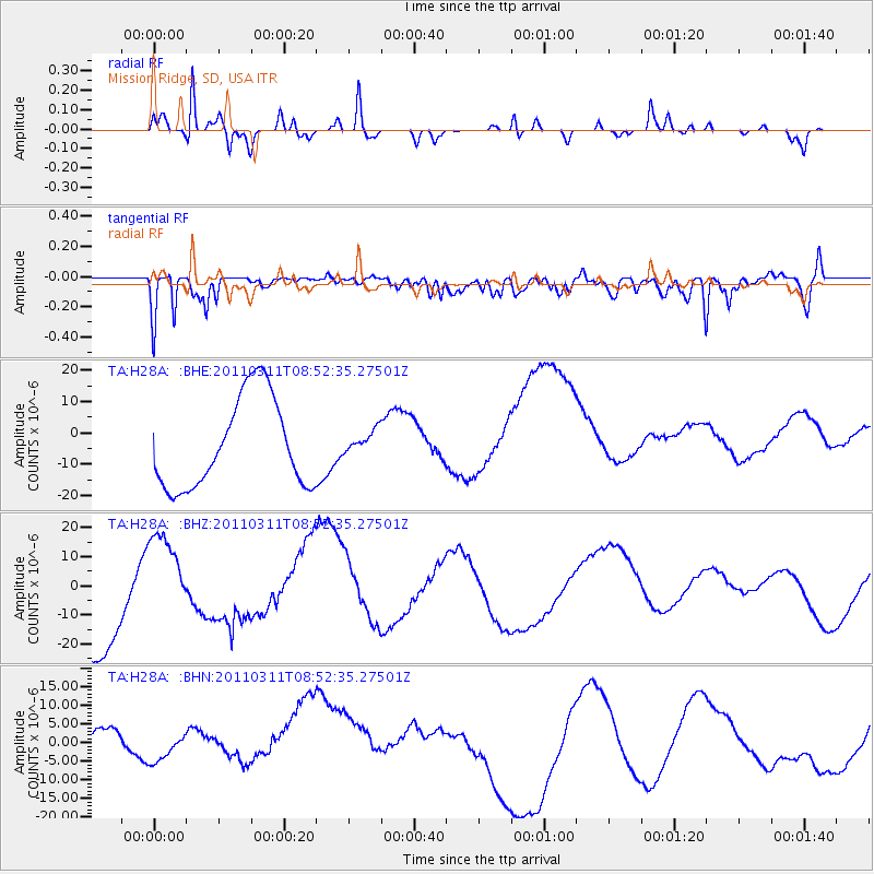
H28A Mission Ridge, SD, USA - Earthquake Result Viewer
*The percent match for this event was below the threshold and hence no stack was calculated.
| Earthquake location: |
Eastern Honshu, Japan |
| Earthquake latitude/longitude: |
37.4/141.0 |
| Earthquake time(UTC): |
2011/03/11 (070) 08:40:56 GMT |
| Earthquake Depth: |
40 km |
| Earthquake Magnitude: |
5.9 MB |
| Earthquake Catalog/Contributor: |
WHDF/NEIC |
|
| Network: |
TA USArray Transportable Network (new EarthScope stations) |
| Station: |
H28A Mission Ridge, SD, USA |
| Lat/Lon: |
44.68 N/101.02 W |
| Elevation: |
642 m |
|
| Distance: |
80.9 deg |
| Az: |
39.64 deg |
| Baz: |
314.63 deg |
| Ray Param: |
$rayparam |
*The percent match for this event was below the threshold and hence was not used in the summary stack. |
|
| Radial Match: |
83.096504 % |
| Radial Bump: |
334 |
| Transverse Match: |
71.0816 % |
| Transverse Bump: |
400 |
| SOD ConfigId: |
356183 |
| Insert Time: |
2011-08-13 21:37:04.172 +0000 |
| GWidth: |
2.5 |
| Max Bumps: |
400 |
| Tol: |
0.001 |
|
Signal To Noise
| Channel | StoN | STA | LTA |
| TA:H28A: :BHZ:20110311T08:52:35.27501Z | 0.6283141 | 1.5222983E-5 | 2.42283E-5 |
| TA:H28A: :BHN:20110311T08:52:35.27501Z | 0.6371337 | 4.8496495E-6 | 7.611667E-6 |
| TA:H28A: :BHE:20110311T08:52:35.27501Z | 0.2644718 | 3.7767534E-6 | 1.4280365E-5 |
| Arrivals |
| Ps | |
| PpPs | |
| PsPs/PpSs | |


