You are here: Home > Network List > TA - USArray Transportable Network (new EarthScope stations) Stations List
> Station I28A Midland, SD, USA > Earthquake Result Viewer
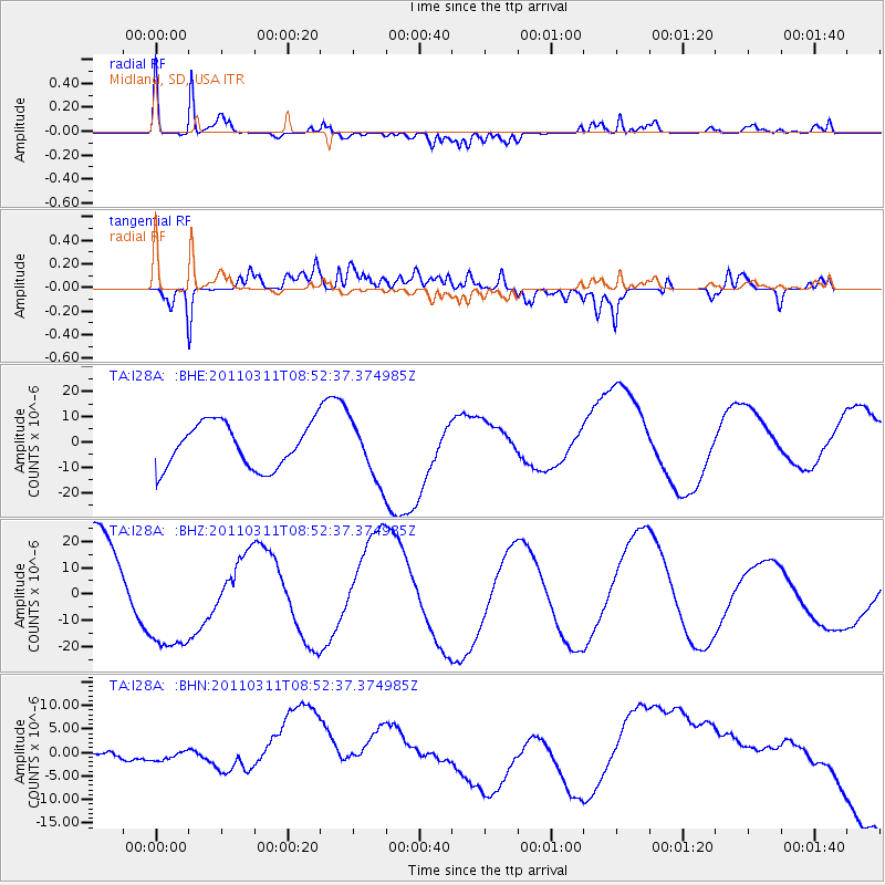
I28A Midland, SD, USA - Earthquake Result Viewer
*The percent match for this event was below the threshold and hence no stack was calculated.
| Earthquake location: |
Eastern Honshu, Japan |
| Earthquake latitude/longitude: |
37.4/141.0 |
| Earthquake time(UTC): |
2011/03/11 (070) 08:40:56 GMT |
| Earthquake Depth: |
40 km |
| Earthquake Magnitude: |
5.9 MB |
| Earthquake Catalog/Contributor: |
WHDF/NEIC |
|
| Network: |
TA USArray Transportable Network (new EarthScope stations) |
| Station: |
I28A Midland, SD, USA |
| Lat/Lon: |
44.00 N/101.17 W |
| Elevation: |
655 m |
|
| Distance: |
81.3 deg |
| Az: |
40.202 deg |
| Baz: |
314.613 deg |
| Ray Param: |
$rayparam |
*The percent match for this event was below the threshold and hence was not used in the summary stack. |
|
| Radial Match: |
73.4188 % |
| Radial Bump: |
400 |
| Transverse Match: |
48.450264 % |
| Transverse Bump: |
400 |
| SOD ConfigId: |
356183 |
| Insert Time: |
2011-08-13 21:37:09.838 +0000 |
| GWidth: |
2.5 |
| Max Bumps: |
400 |
| Tol: |
0.001 |
|
Signal To Noise
| Channel | StoN | STA | LTA |
| TA:I28A: :BHZ:20110311T08:52:37.374985Z | 1.613047 | 2.4214882E-5 | 1.50118885E-5 |
| TA:I28A: :BHN:20110311T08:52:37.374985Z | 0.81554776 | 7.1161453E-6 | 8.725602E-6 |
| TA:I28A: :BHE:20110311T08:52:37.374985Z | 1.332462 | 1.1535183E-5 | 8.657044E-6 |
| Arrivals |
| Ps | |
| PpPs | |
| PsPs/PpSs | |


