You are here: Home > Network List > TA - USArray Transportable Network (new EarthScope stations) Stations List
> Station F29A Eureka, SD, USA > Earthquake Result Viewer
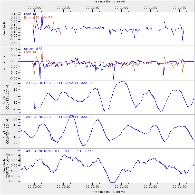
F29A Eureka, SD, USA - Earthquake Result Viewer
*The percent match for this event was below the threshold and hence no stack was calculated.
| Earthquake location: |
Eastern Honshu, Japan |
| Earthquake latitude/longitude: |
37.4/141.0 |
| Earthquake time(UTC): |
2011/03/11 (070) 08:40:56 GMT |
| Earthquake Depth: |
40 km |
| Earthquake Magnitude: |
5.9 MB |
| Earthquake Catalog/Contributor: |
WHDF/NEIC |
|
| Network: |
TA USArray Transportable Network (new EarthScope stations) |
| Station: |
F29A Eureka, SD, USA |
| Lat/Lon: |
45.83 N/99.83 W |
| Elevation: |
575 m |
|
| Distance: |
80.7 deg |
| Az: |
38.206 deg |
| Baz: |
315.246 deg |
| Ray Param: |
$rayparam |
*The percent match for this event was below the threshold and hence was not used in the summary stack. |
|
| Radial Match: |
69.689285 % |
| Radial Bump: |
400 |
| Transverse Match: |
67.273605 % |
| Transverse Bump: |
400 |
| SOD ConfigId: |
356183 |
| Insert Time: |
2011-08-13 21:44:44.962 +0000 |
| GWidth: |
2.5 |
| Max Bumps: |
400 |
| Tol: |
0.001 |
|
Signal To Noise
| Channel | StoN | STA | LTA |
| TA:F29A: :BHZ:20110311T08:52:34.100022Z | 1.764067 | 7.299926E-6 | 4.1381227E-6 |
| TA:F29A: :BHN:20110311T08:52:34.100022Z | 2.131747 | 1.26768E-5 | 5.946672E-6 |
| TA:F29A: :BHE:20110311T08:52:34.100022Z | 0.528173 | 4.1294984E-6 | 7.818458E-6 |
| Arrivals |
| Ps | |
| PpPs | |
| PsPs/PpSs | |


